


Sign up for our free weekly email weather newsletter, featuring weather journalist Kevin Myatt.
UPDATE 9:45 PM, 8/7/2024: Here are a few updates to expectations for Tropical Storm Debby’s impacts in Virginia on Thursday and Friday.
Projections for Tropical Storm Debby’s impact on Virginia have generally moved slightly west and heavier with rainfall, with the Blue Ridge south of Roanoke a particularly intense area that could collect 6-10 inches of rain, locally more, Thursday through early Friday. Upslope flow against the Blue Ridge often creates a locally intense zone of rain with tropical systems that have moved inland. Rainfall of 3 inches or more may extend as far west as Grayson County, Wytheville and Bluefield then along the Virginia-West Virginia border northward. Amounts are expected to gradually lessen to the west of Wytheville in Southwest Virginia and also east of about Farmville and South Boston in Central and Southside Virgina. The middle of Cardinal News’ coverage area — Roanoke, Lynchburg, Martinsville, Danville and west through the New River Valley — appears to the bull’s-eye for heavy rain, with widespread 3-7 inches and some locally higher amounts. 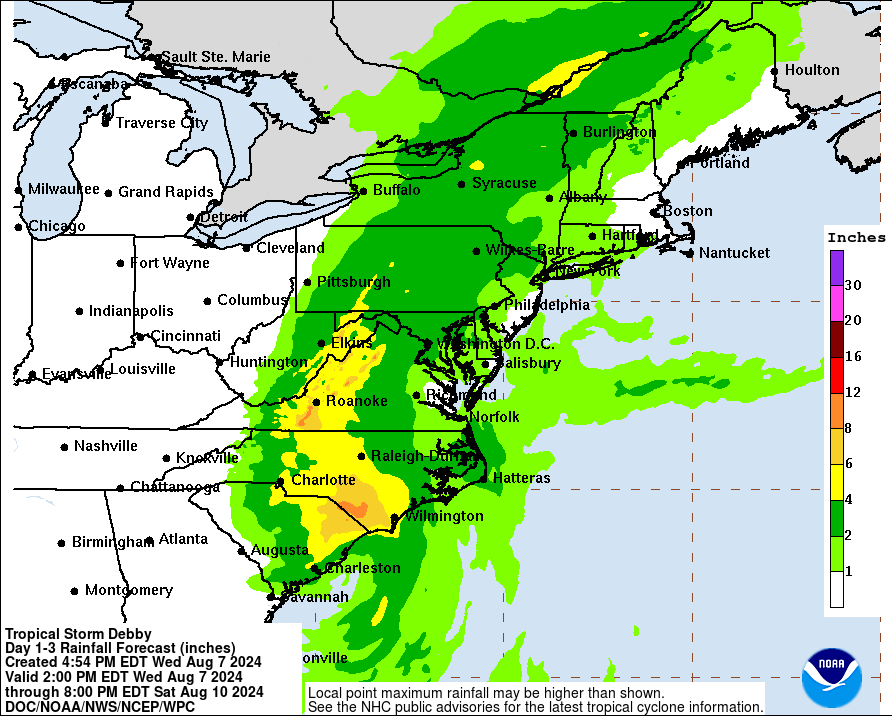
- Flood warnings from Roanoke to Danville: River flood warnings have already been issued for the Roanoke River through Roanoke and the Dan River through Danville. If intense rainfall materializes in the mountains south of Roanoke, the Roanoke River may crest some feet above its 10-foot flood stage at the Walnut Avenue gauge in Roanoke. Heavy rain could also push the Dan River past its 17-foot flood stage in Danville. The crests would probably occur Friday or Saturday following runoff from creeks and other smaller tributaries that may flood more quickly — have a plan to leave quickly if you live near one. A flood watch covers all of Virginia as far west as Grayson, Wythe and Bland counties.
- Tornado risk along U.S. 29: There will be a risk of a few tornadoes along and east of the U.S. 29 corridor (Charlottesville to Lynchburg to Danville and eastward). An isolated tornado cannot be ruled out entirely in some of the heavier rain bands anywhere in Virginia.
- Fast-moving storm: Debby looks to move much faster through Virginia than early projected, with most of the heaviest rain over by sunrise Friday in the southern half of Virginia and out of the state entirely by mid-afternoon Friday as the center of the storm moves north of the state. Some lighter showers may linger into Friday evening.
- Wind risk rises slightly: Tropical Storm Debby has regained 60 mph sustained winds late Wednesday just before a second landfall in South Carolina early Thursday. It is not expected to regain hurricane strength with 74 mph sustained winds, and it will likely become a tropical depression with 39 mph or lesser winds before arriving in Virginia early Friday. The wind increase around the center may slightly raise the risk of a few 45 mph wind gusts when it gets to Virginia, particularly in higher elevations and north and east of the storm center. Sporadic to scattered power outages and some tree damage may occur with stronger wind gusts, sometimes mixed down to the surface in heavier downpours.
* * * END OF UPDATE * * *
After many summer weeks staring at colors depicting deepening drought on Virginia maps, similar vigilance is now in order for viewing the colors marking enhanced risks of flooding as Tropical Storm Debby threatens to bring too much of a good thing too fast to many previously dusty areas of the commonwealth.
Debby, which was a Category 1 hurricane when it came ashore in the eastern Florida Panhandle on Monday, is expected to turn northward for another landfall near Myrtle Beach, South Carolina, by early Thursday, then sweep northward inland toward Virginia with a swath of dense moisture pulled off the warm waters of the western Atlantic Ocean and then lifted and condensed into heavy rainfall in its glide over increasingly higher terrain.
Generally, locations in Virginia along and east of the Blue Ridge Parkway and Skyline Drive can expect 3-7 inches of rain through Saturday morning, though perhaps somewhat less in the eastern fringe of the state. Some locally higher amounts are possible, owing to heavier rain bands that may stall and/or localized terrain effects. West of the Blue Ridge, 1-4 inches is expected as far west as near Bristol and Tazewell, tapering off to below an inch farther west in Southwest Virginia. It is possible the southwest tip of the state in western Lee County will see no little or no rain from Debby. 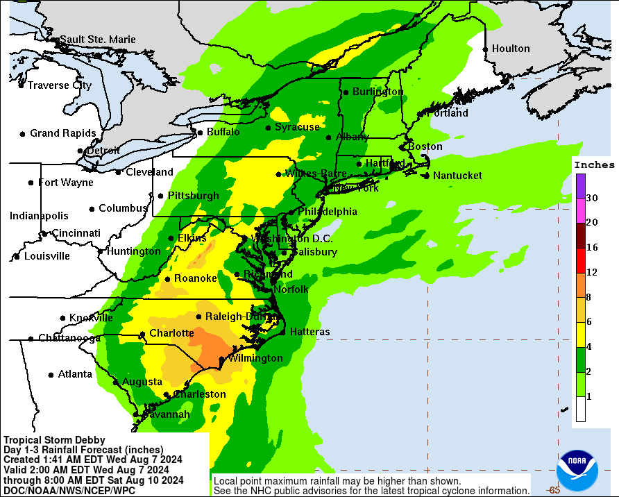
The National Weather Service late Tuesday placed much of Virginia east of the Blue Ridge under a flood watch for Wednesday through Friday with the potential for additional counties to the west to be added later. Also Tuesday, Gov. Glenn Youngkin declared a state of emergency for Virginia ahead of Debby, enabling state resources to be more easily mobilized to respond to potential flooding and power outages.
While a few showers with an outer band of Debby crept into Southside Virginia on Tuesday, more numerous showers and storms will build northwestward into the southern half of Virginia later on this Wednesday, increasing in coverage and intensity through Thursday. The heaviest rain is expected Thursday night and early Friday, as the circulation center of Debby, likely weakened to a tropical depression by then, moves through central North Carolina and then into western and central Virginia.
An approaching cold front and its associated upper-level low-pressure trough will kick Debby out Friday night and Saturday, bringing an end to the rainfall for Virginia on Saturday morning, possibly even before sunrise. Cooler, drier air behind the front will bring noticeable relief from recent summer heat next week. 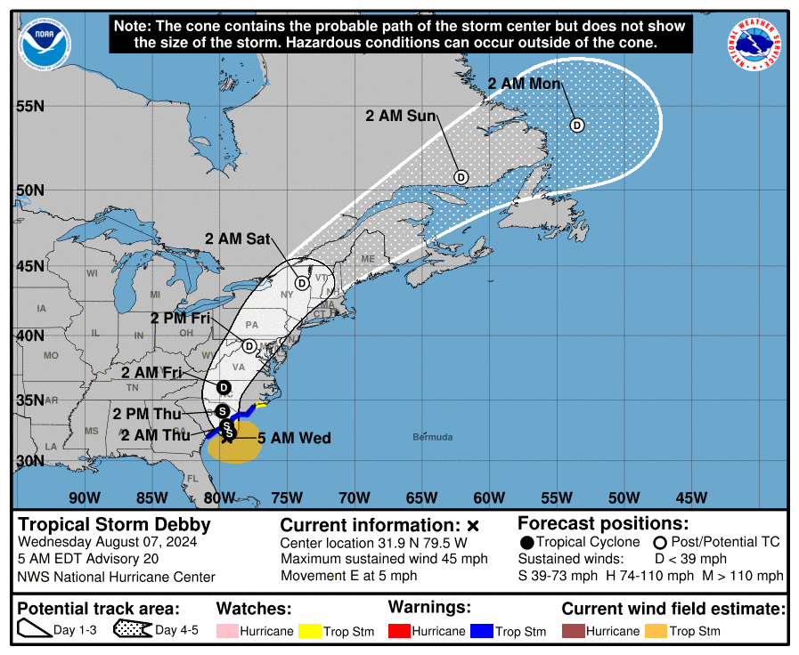
While high winds are not expected to be a major or widespread issue in Virginia with this tropical system, even a few gusts in the 30-40 mph range may be sufficient to topple some trees in wet ground. Trees in our region are naturally braced for more common westerly wind vectors and are often damaged a little more easily by gusts from the east than even stronger winds from the west. Sporadic to scattered power outages may also occur.
Any landfalling tropical system carries at least some risk of producing tornadoes, usually brief and relatively weak twisters embedded in rain bands but capable of damage, as shearing winds aloft translate to the surface. This risk would increase if dry slots form between the squally rain bands, especially if the sun can poke out for a short time, as this sharpens boundaries and increases instability. Some dry air was ingested into the storm on Tuesday, and that may increase the risk of a few tornadoes developing, especially in the eastern half of Virginia, particularly the Hampton Roads area on Friday, where warmth and instability may be greatest and easterly winds aloft in the counterclockwise circulation may create the greatest shear. 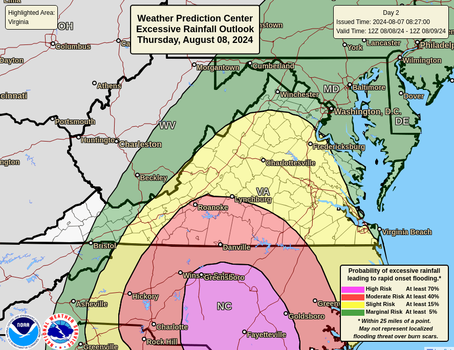
Most of Virginia, especially western and northern sections, enters into this bout of tropical rainfall significantly drier than normal in 2024, even going back to latter half of 2023. However, a couple of weeks of intermittent rounds of thunderstorms over the southern half of Virginia had improved most locations a shade or two on the last U.S. Drought Monitor issued Thursday, Aug. 1, based on data through the previous Tuesday, July 30.
Since then, there have been more splotchy storms in the southern half of Virginia, with Danville picking up 3.45 inches of rain in a single locally intense thunderstorm on Friday. The sporadic nature of the storms means people in some areas are looking forward to what appears likely to be their most substantial rainfall in months, soaking dry ground and refilling wells and dry stream beds, while people in other locations not far from those are dreading the pouring rain when it seems there has already been too much recently.
Northern Virginia is more uniformly dry, especially the Shenandoah Valley westward into northeastern West Virginia, where the drought has been rated “extreme” for the second time in less than a year. A several inches’ soaking is greatly needed in this part of the state. 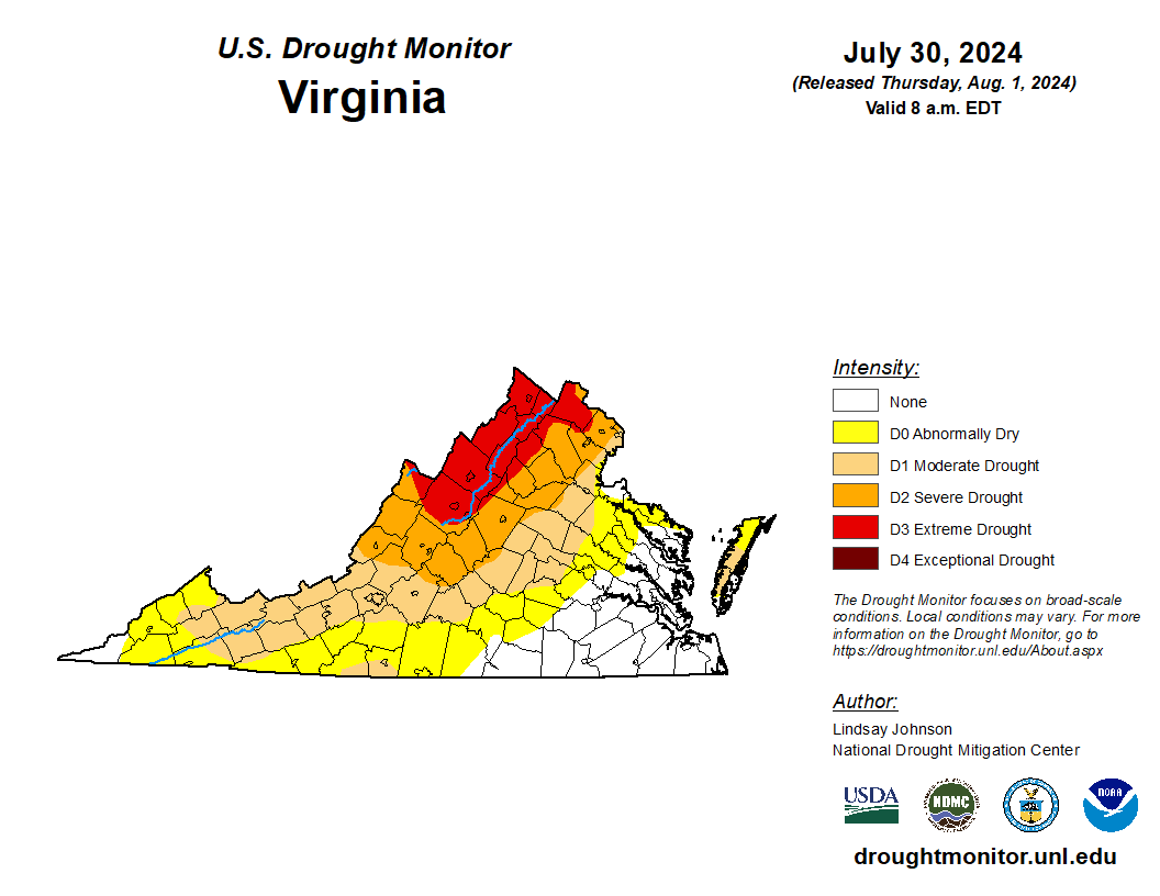
Dryness does create some margin for rain to fall for a while without major flooding in many parts of the state, but intense downpours in a short time can run off fast enough to cause localized flooding even during drought. Small streams, drainages and some roads and streets can be overwhelmed quickly by runoff even when it has been relatively dry. Widespread major river flooding does not appear likely given the preceding dryness and low flows, but some rivers may creep over their banks in days ahead, and more serious river flooding could develop if rainfall is even more intense, or the most intense rainfall is even more widespread, than expected.
One limiting factor for Virginia flooding will be that Debby’s remnants should be moving much faster than the sluggish dawdle that has inundated parts of Georgia and South Carolina. High pressure over the Atlantic and the approaching cold front and trough will combine to shoot Debby’s circulation center rapidly northeastward. By Saturday afternoon, it is expected to be centered over New England or southeast Canada.
The weekend to the middle part of next week will bring days with 50s to lower 60s lows and 70s to lower 80s highs in much of Virginia, and there might even be a morning or two with some 40s lows in outlying parts of western Virginia. More summerlike heat is likely to eventually rebuild. It remains to be seen whether Debby will mark an effective end to long-term, large-scale drought on Virginia, or if following weeks of relative dryness will paint the colors anew across the commonwealth on the drought map. 
Journalist Kevin Myatt has been writing about weather for 20 years. His weekly column, appearing on Wednesdays, is sponsored by Oakey’s, a family-run, locally owned funeral home with locations throughout the Roanoke Valley.
