


Sign up for our free weekly email weather newsletter, featuring weather journalist Kevin Myatt.
It’s “only” a depression. It’s “only” remnants.
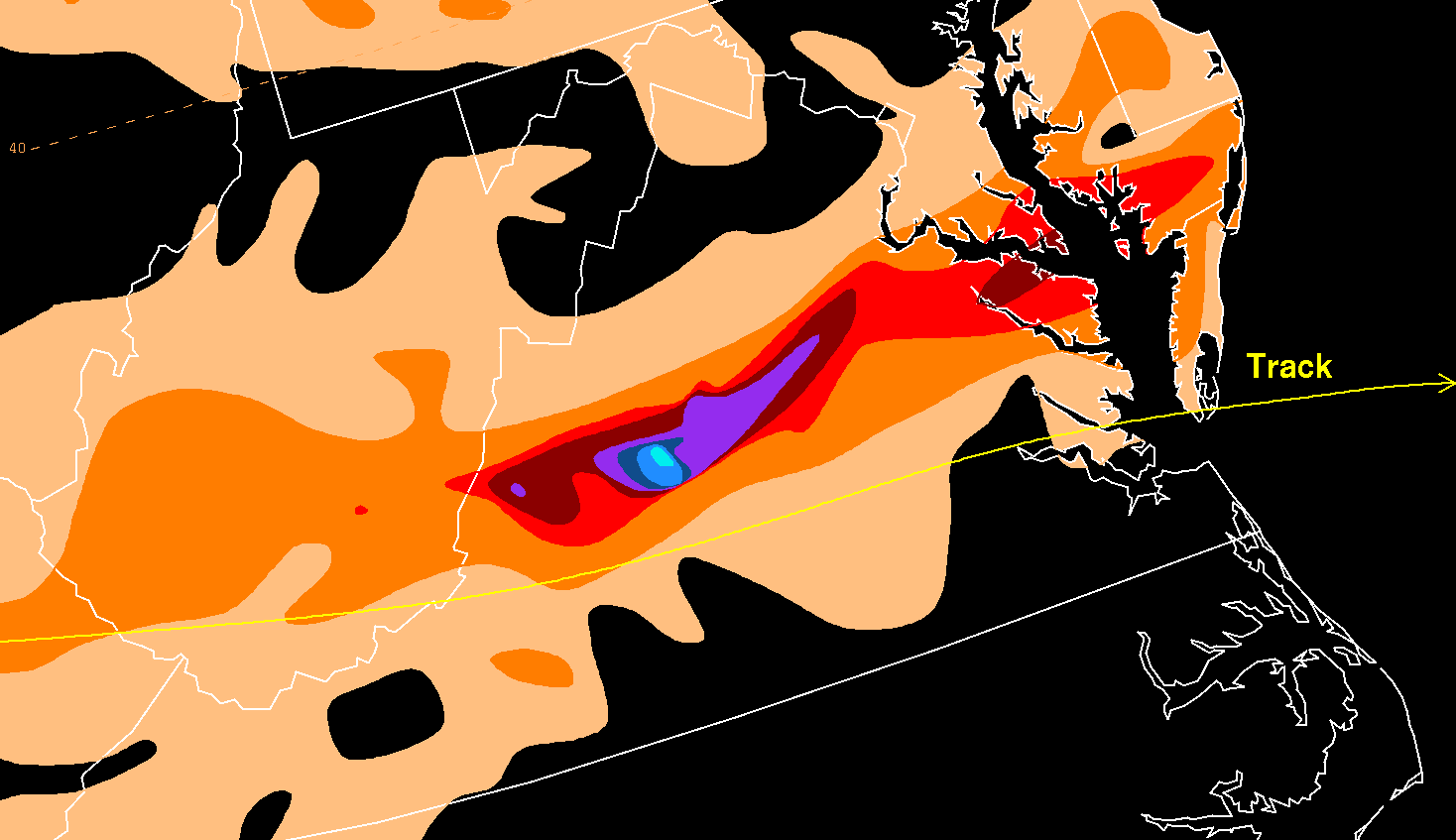
That’s what Camille was, despite some persistent belief to the contrary, 55 years ago this week on Aug. 19-20, 1969, when it devastated much of Nelson County with unimaginable flooding and mudslides, inundated several surrounding counties with deadly flooding, sent the James River to then-record crests downstream at Lynchburg and Richmond, and killed well over 100 people.
No, it was not really “Hurricane Camille” when it reached Virginia in 1969. Camille approached and entered Virginia as a tropical depression, according to National Hurricane Center tracking from the time, and historical markers even refer to the “remnants of Hurricane Camille.” Although an extremely powerful Category 5 hurricane at its Mississippi landfall, Camille had long lost the 74 mph sustained winds necessary for hurricane status, not even carrying 39 mph winds necessary to be a tropical storm past the Mississippi-Tennessee border on its curving path north and then east toward Virginia.
Also, Camille never stalled over Virginia, as has sometimes been stated. Its circulation center kept a steady eastward pace across Virginia before re-emerging over the Atlantic, where it quickly regained tropical storm strength. Extremely heavy rain stalled over Nelson County and nearby localities as a cluster of thunderstorms continually regenerated against the Blue Ridge. Camille itself did not stall. 
What isn’t fallacy about Camille in Virginia are phenomena that seem far more outlandish than technical semantics about its storm structure or movement.
Entire mountainsides turning to slurry and sliding off — more than 3,000 mudslides occurred. Tiny drainages becoming roaring rivers and dislodging houses. People having to cup hands over their noses and mouths to be able to breathe amid a waterfall from the clouds. Barrels filled with over 30 inches of water solely from Camille’s downpour in less than 12 hours. All that really happened.
And, sadly, at least 124 people were killed in Virginia, with some accounts as high as 153, mostly but not entirely in Nelson County, adding to a similar number of deaths that occurred along the Mississippi Gulf Coast where nearly 200 mph winds and 24-foot storm surge roared ashore. This makes Camille the most deadly weather disaster in the known history of Virginia as an American state or British colony. 
No other weather event in Virginia history has stirred so much cultural interest in its aftermath, as at least 11 books have either been written about Camille’s impact on Virginia or devote substantial space to it.
The Nelson County Historical Society web page linked here lists all 11 of those books and links to three songs and numerous articles on media web sites devoted to Camille in Virginia. (This writer has a Roanoke Times weather column on the list, and also worked as an editor of the book “Hurricanes and the Middle Atlantic States,” copyright 2005 by author Rick Schwartz, that recapped the Camille disaster among many other hurricanes that have affected Virginia, directly or as remnants.)
At the 50th anniversary of the Camille disaster in 2019, several media outlets did extensive recaps and collected survivor’s memories — many of those can be found in the above link to the Nelson County Historical Society. 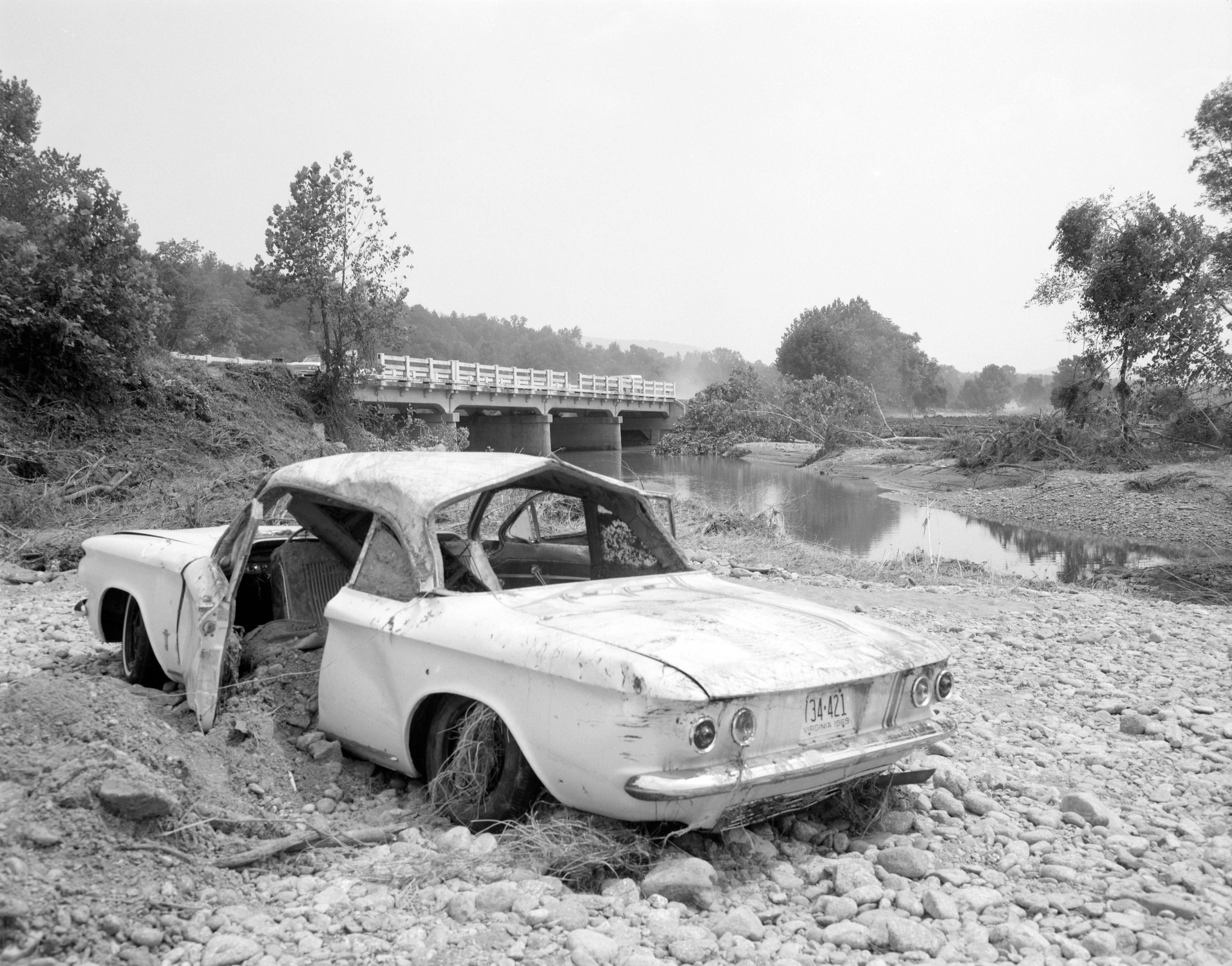
Why was Camille different?
The main difference between Camille’s impact on Virginia and that of most other tropical systems that have affected the commonwealth, including several that were themselves quite deadly and destructive, was the narrowly focused extremely intense rainfall — over 27 inches of rain has been widely accepted as the highest measured total, but over 30 inches likely fell in some places based on accumulation in barrels — occurring in fewer than 12 hours over a small geographic area focused on Nelson County.
Typically, tropical systems — such as the former Tropical Storm Debby just a couple weeks ago — spread a much wider area of moderate to heavy rain, with some narrower zones of intense rainfall, often peaking at about 6-10 inches but sometimes a little more. 
Some factors that cumulatively led to such a firehose of tropical rains developing with Camille include:
- Thick moisture carried inland by Camille’s circulation that hadn’t been rained out previously. It is interesting to note that aside from 5-10 inches near the Gulf Coast at landfall, most of the rainfall amounts along Camille’s track inland were in the 1- to 3-inch range, not enormous amounts we commonly see with inland-tracking tropical systems, meaning there was still a lot of tropical moisture to wring out when it reached Virginia.
- Pre-existing saturated soils and high low-level atmospheric moisture from a soggy summer.
- The jet stream aloft being quite strong, which is why Camille didn’t stall. As meteorologist Jeff Halverson notes, a streak of fast jet stream winds aloft enabled additional lift over Central Virginia overnight on Aug. 19 and early Aug. 20.
- A slow-moving cold front pressing in from the north further increased lift and narrowed the track of Camille’s most intense rainfall.
- Camille’s counterclockwise circulation and approach from the west resulting in easterly wind trajectories that banked dense moisture against the Appalachians, with Nelson County becoming a particular focus for this upslope effect. Storms formed along the mountains, rained themselves out as they moved off, and then regenerated along the Blue Ridge, repeating the cycle until Camille’s center had passed and drying westerly winds began.
- Camille possibly already starting to restrengthen as a tropical system as it crossed Virginia, drawing in warm, moist air off the Atlantic. Its quick resurgence to a tropical storm just offshore could be indicative of this.
Halverson has an excellent and much more detailed recap of the atmospheric dynamics at play in Camille’s flooding, linked here, that has been reposted multiple times for the Washington Post’s “Capital Weather Gang.” 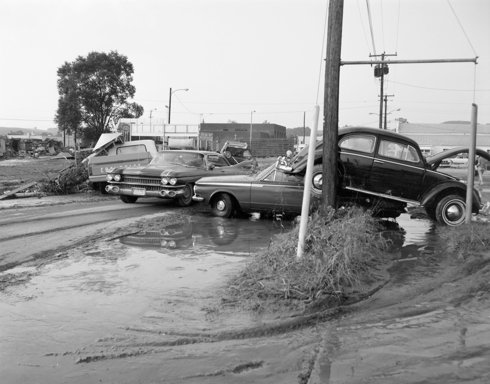
Not disastrous for most of Virginia
While it is widely understood that Camille’s focus of horrific flooding was centered on Nelson County — sometimes at the exclusion of other localities that also suffered like Buena Vista in Rockbridge County — it might be surprising how little rain fell in other parts of Virginia with Camille.
Official rainfall at Charlottesville just to the north and at Roanoke, Lynchburg, Blacksburg and Richmond along the U.S. 460 corridor to the south fit within the 1- to 3-inch range, comparable to or even somewhat less than what we just got with Tropical Storm Debby two weeks ago.
Danville barely broke half an inch with Camille, and Norfolk didn’t get quite half an inch.
Share your story
Were you or your family touched by Camille? Share your stories or photos for possible publication:
news@cardinalnews.org.
It is easy, with only slight toggles in the atmospheric particulars, to imagine this catastrophe unfolding over the Interstate 64 corridor, inundating Staunton, Waynesboro and Charlottesville, or else sinking more southward and parking along U.S. 460 and sliding hillsides into the New River Valley, the Roanoke Valley, and the Lynchburg area. Focused on a primarily rural area with sparse population, Camille’s death toll still reached triple digits, roughly 1 percent of Nelson County’s 12,000 population at the time.
Suzanne Crockett, now in Spring Hill, Florida, wrote me about her experiences traveling from a less directly affected part of Virginia across more heavily damaged areas.
“It was the summer before my junior year at Culpeper County High School,” Crockett recalled. “I was at a Girl Scout camp near Roanoke, in a lovely little valley that would have turned deadly if Camille had hit more directly. We survived, wet but unscathed. The drive home was heartbreaking, seeing so much damage. But the worst was listening to the reports on WRVA about Nelson County, and the pictures in the Richmond Times Dispatch.” 
Not the first or last tropical impact
Camille’s monetary damage toll in Virginia has been estimated at $116 million in 1969 dollars, which translates to nearly a billion dollars in 2024. In total, 313 houses, 71 trailers and 430 farm buildings were destroyed, according to a National Weather Service recap.
Hurricane Isabel in 2003 is considered the state’s most destructive disaster in terms of monetary damage at nearly $2 billion. Isabel entered southeast Virginia still a hurricane from an Outer Banks landfall at Category 2 strength and affected the entire state except the southwestern corner with high winds and heavy rain, whereas Camille’s wrath was focused much more narrowly but with almost unimaginably intense rainfall.
There is little correlation between the landfalling strength of a hurricane and how much flooding it causes this far inland.
Hurricane Juan of 1985 and Hurricane Agnes of 1972 were both Category 1 storms on the Gulf Coast, the weakest hurricane level, and yet their inland remnants caused widespread and deadly flooding in Virginia and nearby states. In fact, the record James River crest at Lynchburg of 35.5 feet set by Camille was surpassed by almost seven feet in 1985, while the record 28.6-foot crest at Richmond set by Camille was surpassed twice, just three years later by Agnes in 1972 (36.5 feet) and then again by Juan in 1985 (30.76 feet). Broad, very heavy rainfall covering more of the state brought on worse flooding of the James than narrowly focused epic rainfall. 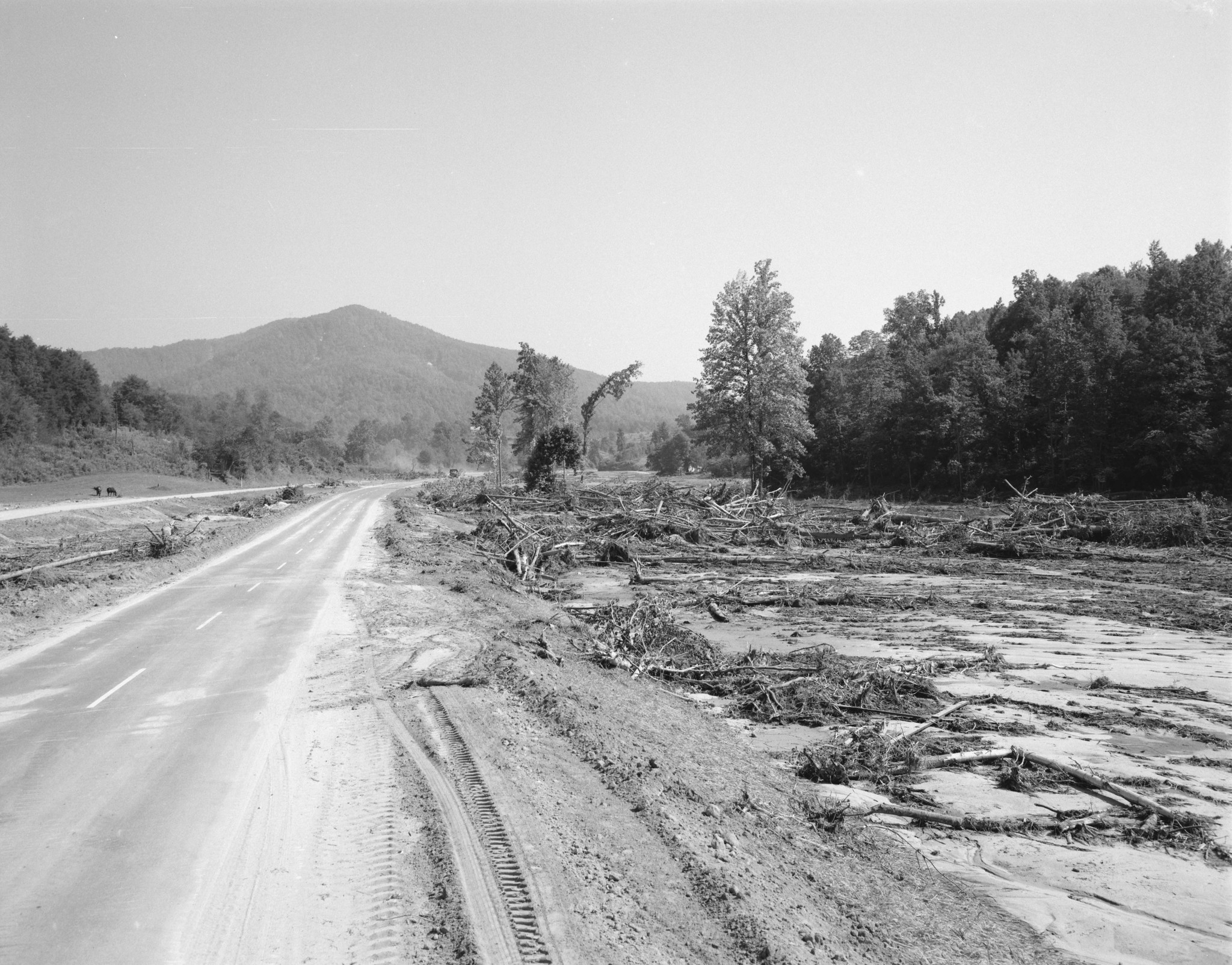
Hurricane Katrina, however, very much a worthy sequel to Camille some 36 years later in 2005 — similar landfall point in Mississippi, Category 5 peak though it was Category 3 at landfall, storm surge that actually beat some of Camille’s records because of its greater size — also affected Virginia on its inland route but didn’t even get into the remote ballpark of what Camille did with heavy rainfall, even though there was some fear beforehand that it would do exactly that.
Which gets to a key point about tropical weather and flood forecasting.
Predicting whether, when and where a Camille-like catastrophic megaflood affecting such a small geographic area might occur is beyond the realm of present-day meteorology and likely to remain so for decades to come. Too much has to come together just exactly so over a relatively small area. 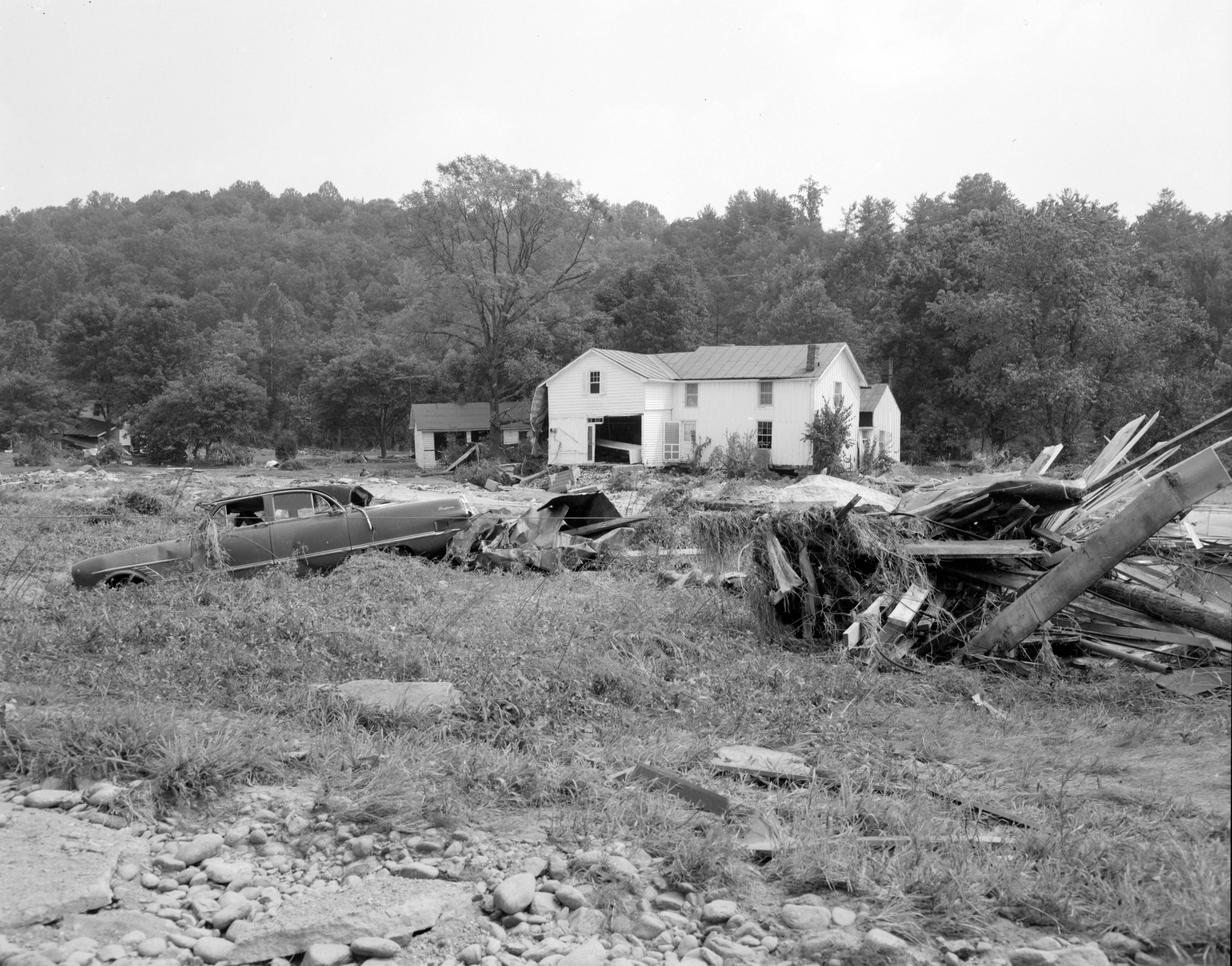
Getting 2 to 3 feet of rain in a few hours may be considered a once-in-a-millennium event, but even 8 to 12 inches, or less than that if prior conditions are saturated, can cause high-end flash flooding. (Check out what just happened in Connecticut with up to a foot of rain.) Many climate studies suggest that events with several inches of rain pouring over a local or regional area in a short time are becoming more frequent at farther north latitudes as a warming climate increases precipitable moisture levels in the atmosphere.
Forecasting generally when and where heavy rain capable of causing at least some flooding with an inland tropical system or other atmospheric setup 1-3 days in advance is well within the capability of modern meteorology. Within the broader area of potential flooding, there can always be narrow zones of more intense rainfall that cause major to extreme flooding with little notice. Pinpoint short-term warnings involving Doppler radar (perhaps eventually phased-array radar), remote instrumentation and on-the-ground observations, plus individual and community vigilance and preparedness, become critical.
This is why forecasters and weather communicators may sometimes seem a little overly nervous with just about any inland tropical system. In Virginia, we remember, or at least have studied, Agnes in 1972, Juan in 1985, Isabel in 2003, Jeanne in 2004, Michael in 2018 … and Camille in 1969.
Debby in 2024 could have done something similar to one of these somewhere in our commonwealth — we’re blessed many factors didn’t line up so it could.
“Only” a Category 1 at landfall, “only” a depression or “only” remnants of a once mightier hurricane are sometimes enough for a once-in-a-lifetime or once-in-a-millennium catastrophe. 
See also: “Coolest August temperatures in decades visit parts of Virginia.”
Journalist Kevin Myatt has been writing about weather for 20 years. His weekly column, appearing on Wednesdays, is sponsored by Oakey’s, a family-run, locally owned funeral home with locations throughout the Roanoke Valley.
