


UPDATE 6PM, 9/16/2024: The low-pressure system has come ashore in South Carolina without becoming Tropical Storm Helene — that name will get saved for a later storm. There were some wind gusts up to 60 mph with its arrival but it never developed a closed, warm-core tropical center, so it never became a tropical storm, just remained a “regular” baroclinic low-pressure system. Nevertheless, there were widespread flooding problems in the Wilmington and Cape Fear areas of North Carolina with more than 10 inches of rain northeast of the circulation center as it came ashore. Rain is spreading across North Carolina and starting to edge into southern Virginia at this early Monday evening update. With the low expected to track more west-northwest than northwest before dissipating, and cool, dry high pressure to the north wedging in a little stronger than earlier anticipated, there has been a slight reduction of expected rainfall amounts in Virginia, though most areas aside from the northern and some western fringes are still expected to top 1 inch by Wednesday. Some areas along the Blue Ridge south of Roanoke may total more than 4 inches with upslope enhancement. END UPDATE
Dryness has become widespread again across Virginia and a tropical system moving northwest from the Carolinas looks primed to offer significant relief with at least some risk of flooding.
A low-pressure system off the Southeast U.S. coast that is expected (but not certain) to become Tropical Storm Helene on Monday is projected to angle northwest after landfall and spread bands of rain over much of Virginia — perhaps excluding the southwest tip, again — late Monday into Tuesday. Widespread amounts of 1-3 inches appear likely as far west as the Interstate 77 corridor in Southwest Virginia and into eastern West Virginia, with the potential for localized greater amounts especially where upslope flow against the Blue Ridge may locally enhance amounts or wherever a heavier rain band can stall for longer.
If this sounds mighty familiar, well, we can do a quick rewind back to Tropical Storm Debby about 40 days ago for a remarkably similar situation. The major differences are that Debby was a far more developed system with a more intense history as a prior hurricane, with incumbent expectations of greater rainfall amounts, and Debby already had flight plans filed for Newfoundland when she came ashore in the Carolinas and zipped across Virginia. The current system is still developing and may stall or dawdle around the Carolinas and Virginias with intermittent showers for days ahead.
UPDATED MAP AS OF MONDAY 6:20 p.m.: 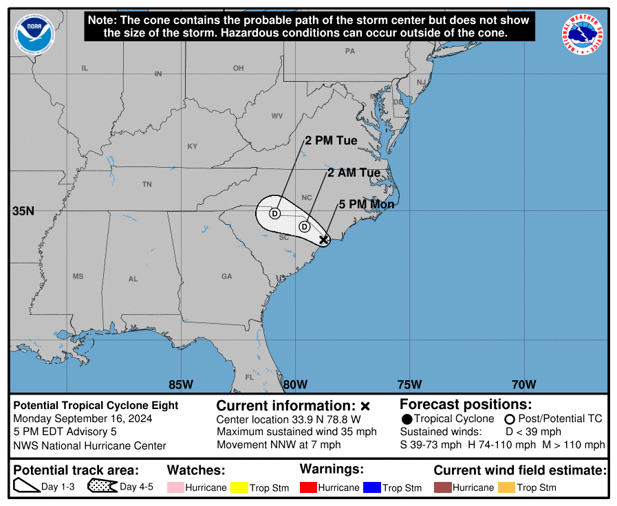
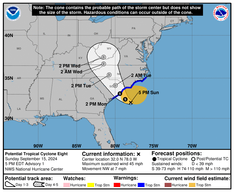
As of Sunday evening, the system in question bore the inelegant name “Potential Tropical Cyclone Eight” or the Star Wars droid-like moniker “PTC8.” It is expected to become Tropical Storm Helene by sometime on Monday — perhaps even before you read this clicking off the Monday Cardinal newsletter — and then make landfall generally between Charleston and Myrtle Beach, South Carolina, by Monday afternoon or evening.
It is largely inconsequential whether it becomes Helene or not. As of this early Sunday evening writing, it is already a broad non-tropical low pressure with strong enough winds, 45 mph, to qualify it as a tropical storm if it were to develop a closed warm-core circulation. Sunday evening, it was a non-tropical low primarily driven by juxtaposed air masses along a frontal boundary.
Even as a non-tropical low or a hybrid “subtropical” low exhibiting both tropical and non-tropical characteristics, it would still be expected to move northwest and spread bands of windy rain through the Carolinas into Virginia. PTC8/Helene has little or no chance to reach hurricane status with 74 mph sustained winds before landfall.
Incidentally, we are moving from the F storm Francine, the Category 2 hurricane that made landfall over Louisiana last week then dissipated near Little Rock, to the H storm, Helene, because the G name, Gordon, got applied to a tropical storm out in the open Atlantic that at this point is, itself, floundering.
PTC8/Helene is sort of an offshoot of Francine, as the broad low-pressure area over the South related to Francine’s inland withering and a frontal boundary it helped lift northward have contributed to the formation of new spin off the coast of the Carolinas. It is, however, a distinctly new circulation center from Francine, so gets a fresh name. 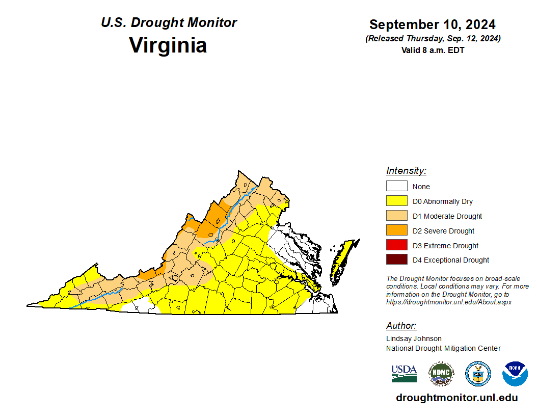
As preceded Debby, Virginia soil is dry, with about the northwest half of the state in moderate to severe drought. The new storm will have to pour a lot in a short time to overcome that dry soil for significant flooding in a particular area, but that is at least enough of a possibility to be monitored closely. Parts of North Carolina are already under a flood watch, and it would not be surprising if these were expanded northward into Virginia on Monday.
But for the most part, the present coastal storm will be viewed as a potential great help to curtail increasingly dry conditions across the commonwealth. As the weeks after Debby have proven, a tropical system moving inland from the Carolinas isn’t a silver bullet against drought, but it can kick the can down the road a little farther as we wait to see whether a pattern change might bring more moisture deeper in the fall.
Journalist Kevin Myatt has been writing about weather for 20 years. His weekly column, appearing on Wednesdays, is sponsored by Oakey’s, a family-run, locally owned funeral home with locations throughout the Roanoke Valley. Sign up for his weekly newsletter:
