


UPDATE 6 P.M. SUNDAY:
- Sunday afternoon brought a rash of tornado warnings on a series of small cells with tight rotation in Henry, Franklin and Pittsylvania counties. It is unclear at this point if any tornadoes touched down.
- A flash flood warning also was issued for the city of Martinsville after strong storms dumped heavy rain in a short time. Another flash flood warning affects a small sliver of northern Patrick County into central Floyd County. A flood watch is in effect Sunday night from Roanoke, Craig, Bedford and Botetourt counties northward through the Shenandoah Valley. where there is some potential for locally heavy rain amid widespread light to moderate showers. The tornadoes and new flooding risk are from the continued effects of the remnants of Hurricane Helene that were absorbed into a broad upper-level that is slowly moving eastward.
- Steady progress continues to be made in restoring power to Southwest Virginia, as the total number of Virginia households and businesses without power has been halved from 240,000 at its peak on Friday night to 118,000 as of 5:30 p.m. Sunday. Power outages now number in the hundreds of households in Franklin, Bedford and Montgomery counties after once being in the thousands, and Roanoke County has seen power restored to about 7,000 since Friday, with 3,409 still in the dark. Power outages now affect less than half of all utility customers in Washington County and about half in Smyth County after affecting a much greater percentage the last two days. Grayson County continues to have essentially a countywide power outage, and two-thirds or more of Bland, Carroll, Russell, Scott and Tazewell counties continue to have no electricity.
END UPDATE
* * *
UPDATE 8:30 A.M. SUNDAY:
- The National Weather Service has delineated much of western Virginia with having a slight risk of flash flooding later on this Sunday through Monday, as an upper-level low containing some of the remnants of Hurricane Helene moves eastward. The rain will generally be showery and less than a half-inch for most. A few spots may get an inch or more quickly in stronger thunderstorms, which could cause localized flash flooding as it falls on top of saturation from Helene last week. Dry weather is expected to return for the latter half of the coming week.
- Gov. Glenn Youngkin, who visited Damascus on Saturday, will tour additional flooded areas on Sunday, his office said.
- About 140,000 Virginia households and businesses remain without power as of 7:30 a.m. Sunday, according to utility data aggregator poweroutage.us. This is down from 240,000 on Friday evening and 190,000 on Saturday morning. Grayson County remains almost totally without power, and more than half of Bland, Carroll, Russell, Scott, Smyth and Tazewell counties haven’t had power restored. The vast majority of the remaining power outages in Virginia are along and west of the Blue Ridge and south of Interstate 64. For a more detailed view of current power outages in Virginia and elsewhere, click on poweroutage.us linked here.
- A second tornado has been confirmed by the National Weather Service office in Blacksburg. An EF-1 tornado with 105-110 mph winds covered a path 1.24 miles long and 150 yards wide from 3 miles southwest of Bedford to 2.75 miles west-southwest of Bedford, the weather service determined. The tornado first touched south of the intersection of Dickerson Mill Road and Hobby Drive, causing minor roof damage to one home, then moved north-northwest parallel to Fiddler Creek Road, leaving a path of tree damage, finally lifting near Wheeler’s Ridge Road. A slightly stronger EF-2 tornado had previously been confirmed near Dry Fork in Pittsylvania County, injuring one person, damaging 30 structures and destroying a mobile home.
- The New River is back within its banks at Allisonia, Galax, Glen Lyn and Radford. The river remains high with debris floating and collecting in deposits. New River Trail State Park is closed due to storm damage.
- Due to widespread devastation in western North Carolina and continued communication and transportation disruption, Appalachian State University and Western Carolina University have announced that classes will be suspended until Oct. 4, while the University of North Carolina at Asheville will discontinue classes until Oct. 9.
END UPDATE
* * *
UPDATE 3:30 P.M. SATURDAY:
- A second fatality has been confirmed related to Helene’s impacts on Southwest Virginia. A person died at Tazewell while cleaning debris Friday when a large tree blew over, according to a National Weather Service storm report. A blown-over barn and large tree killed a woman in Craig County.
- One person was injured in an EF-2 tornado with winds of up to 118 mph that has been confirmed by a National Weather Service survey in Pittsylvania County. The tornado’s path was 225 yards wide and 6.85 miles long from 6 miles west of Chatham to 3 miles west-southwest of Dry Fork. About 30 structures were damaged, the weather service said, with one mobile home destroyed. The National Weather Service office in Blacksburg issued 21 tornado warnings on Friday.
- Power outages in Virginia have been reduced by 20,000 households to about 170,000 at 3 p.m., according to utility data aggregator poweroutage.us. Most localities along and west of Interstate 77 continue to have 50 percent to 99 percent of their utility customers without power.
- A boil-water order has been issued for the St. Clairs Creek service area of the Smyth County Water Department. A tank ran dry during a storm-related power surge, state health officials determined.
- Bristol Motor Speedway has opened its Medallion Campground for flood evacuees. Bathrooms are available.
- Wythe County has opened an emergency shelter at Fort Chiswell High School.
- In Pulaski County, local first responders and swift-water rescue teams from Fairfax, Rockingham County and Lynchburg are continuing to rescue people who are stranded in their homes in the Hiwassee, Allisonia, and Parrott areas of the county, according to a news release from the county. River levels at the Allisonia and Radford gauges have gone down, however, waters are expected to remain at flood stage through Sunday and into Monday.
END UPDATE
* * *
The sun is peeking out on this Saturday, rivers are receding and tens of thousands fewer people are without power than was the case Friday night.
But the task ahead is huge across Southwest Virginia, assessing and cleaning up from widespread flooding and wind damage after days of heavy rain ahead of Hurricane Helene followed by the direct effects of the storm itself Friday. Helene’s slowly weakening inland circulation passed just to the state’s south and west before being absorbed into a sprawling upper-level low that will affect us again in the next few days. 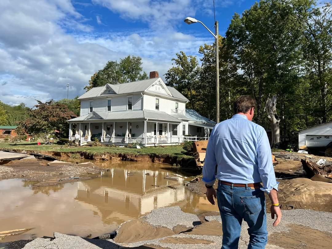
Rain totals for the week of 4 to 10 inches were common near and west of the Blue Ridge, with some totaling over 10 inches west of Interstate 77. Easterly wind gusts on Friday frequently topped 40 mph for as long as six to eight hours, with gusts over 60 mph measured at Hillsville and Grayson Highlands State Park, downing thousands of trees across the region.
There has been at least one fatality, as a female resident of a property near Abbott in Craig County died when a barn and large tree were blown over by high winds. The report from the National Weather Service also said two sheriff’s deputies were injured at the site investigating the situation.
Southwest Virginia’s troubles are just one piece of a mosaic of destruction and heartbreak stretching from the Florida Gulf Coast, through Georgia, the western Carolinas, eastern Tennessee and even into the Ohio Valley. North Carolina officials are urging no one to travel through the western part of that state, where highway access to Asheville was entirely cut off by record flooding, fallen trees, mudslides and washed-out bridges and roadways.
In total, some 4.5 million are without power in 10 states affected by Hurricane Helene and its inland remnant circulation.
As of 9 a.m. Saturday, utility data aggregator poweroutage.us reported that about 190,000 Virginia utility customers were without power, the vast majority of those near and west of the Blue Ridge. More than 90% of customers were without power in Bland, Grayson and Russell counties, with two-thirds or more out in Carroll, Smith, Washington, Tazewell and Scott counties. About half of Wythe County was without power, and about 10,500 were without power in Roanoke County, or about one-quarter of the metropolitan but mountainous locality. “Customers” refers to individual homes and businesses, so multiplied by the number of people actually living in those homes or patronizing those businesses, the human impact is threefold or more greater.
Appalachian Power, which has by far the most customers of any utility in Southwest Virginia, said it has 2,500 employees currently dedicated to power restoration with additional crews arriving this weekend from Ohio, Indiana, Michigan, Oklahoma and Texas.
The New River is slowly receding after its biggest flood since a year before Pearl Harbor. At Radford, it crested at 31.03 feet early Saturday, trailing only the epic 35.96 crest on Aug. 14, 1940, also caused by hurricane remnants wringing out torrents on western North Carolina and Southwest Virginia mountains. Drone footage showed parking lots and outdoor athletic facilities near Radford University completely inundated by floodwaters.
The Roanoke River made a quick rise above flood stage as water ran off Poor and Bent mountains, peaking at 13.15 feet at the Walnut Avenue bridge in Roanoke, 3.15 feet above flood stage, the highest crest in four years and the 20th highest in records that go back to 1901. But the river had already receded back within its banks to 6 feet at the Walnut Avenue gauge on Saturday morning.
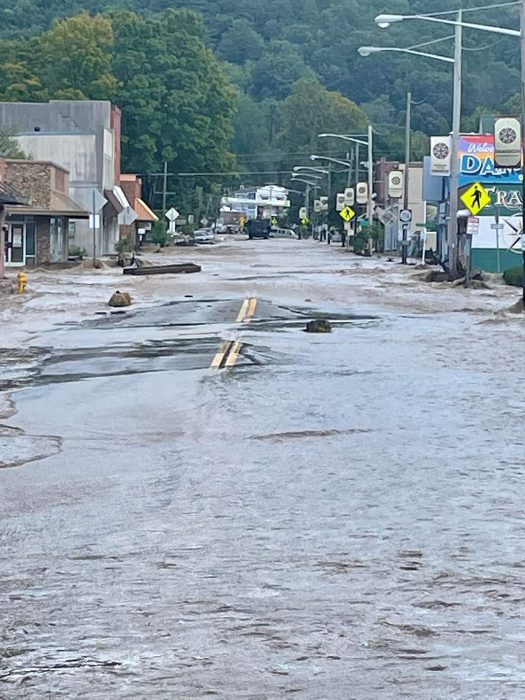
Beyond the main stem rivers, the most extensive damage from flooding is likely to be found near creeks and small streams that rose rapidly with runoff. The town of Damascus, a popular outdoor tourist destination along the Appalachian Trail in Washington County, suffered major damage when Laurel Creek rose 13 feet in minutes on Friday.
Gov. Glenn Youngkin visited Damascus on Saturday morning to survey the damage.
The National Weather Service in Blacksburg issued 21 tornado warnings Friday as tight rotation was detected by radar in rain bands and isolated storm cells within the high-shear northeast quadrant of Helene’s circulation. Surveys will be conducted to determine how many tornadoes actually touched down, with Dry Fork in Pittsylvania County and a location just west of Bedford appearing likely to be two spots suffering tornadoes.
As assessment and cleanup continues in days ahead, Helene’s effects will continue to be felt in the atmosphere. An upper-level low that absorbed Helene’s leftover spin and moisture will drift eastward, bringing showers and thunderstorms back to our region by late Sunday into Monday. The impacts are not expected to be nearly as severe as over the past week, but more rain — coveted not long ago as the region experienced varying stages of drought — is not something that will be enjoyed by our region’s residents who have suffered during Helene. 
