


“As meteorologists, we always want to get the forecast right. This is one we wanted to get wrong.”
Forecasters at the National Weather Service’s office in Greenville-Spartanburg, S.C., which covers most of the western Carolinas including Asheville, grieved their accuracy in a public letter issued Saturday, offering their heartfelt support for the region’s suffering residents and rescue personnel on the front lines after the catastrophic hit by the inland effects of Hurricane Helene. “We live here, too,” forecasters reminded readers.
On Thursday evening, the same forecast office had plastered an all-caps headline, “CATASTROPHIC FLOODING AND LANDSLIDES FOR THE MOUNTAINS AND FOOTHILLS FROM HURRICANE HELENE,” on a weather statement that warned: “This will be one of the most significant weather events to happen in the western portions of the area in the modern era. … We cannot stress the significance of this event enough.”
I’m a two-decade chronicler of regional weather with the written word, not a degreed meteorologist, but I feel similarly. Thursday night, I typed “Hurricane Helene poised for Apalachee Bay to Appalachians disaster” for a headline to a storm preview article in Cardinal News that was overwritten on Friday when we made our first storm updates to describe early reports of power outages, death and injury from Helene’s effects on our own Cardinal News coverage area of Southwest and Southside Virginia.
“Record river crests, rampant mudslides, and widespread wind damage and power outages are expected in that region just to our south,” that article warned. “Southwest and Southside Virginia will be one or two rings outside the bull’s-eye of worst effects.”
We were one or two rings out from the very worst, and it was still very, very bad. Seeing photos of the wreckage in Damascus and the acres of debris in Claytor Lake, and knowing that two people lost their lives in our region during Friday’s tropical tempest, let alone all the heartbreaking images and accounts from our neighbors to the south, I wish it had been otherwise and today’s weekly weather column was about how Helene didn’t live up to its potential. 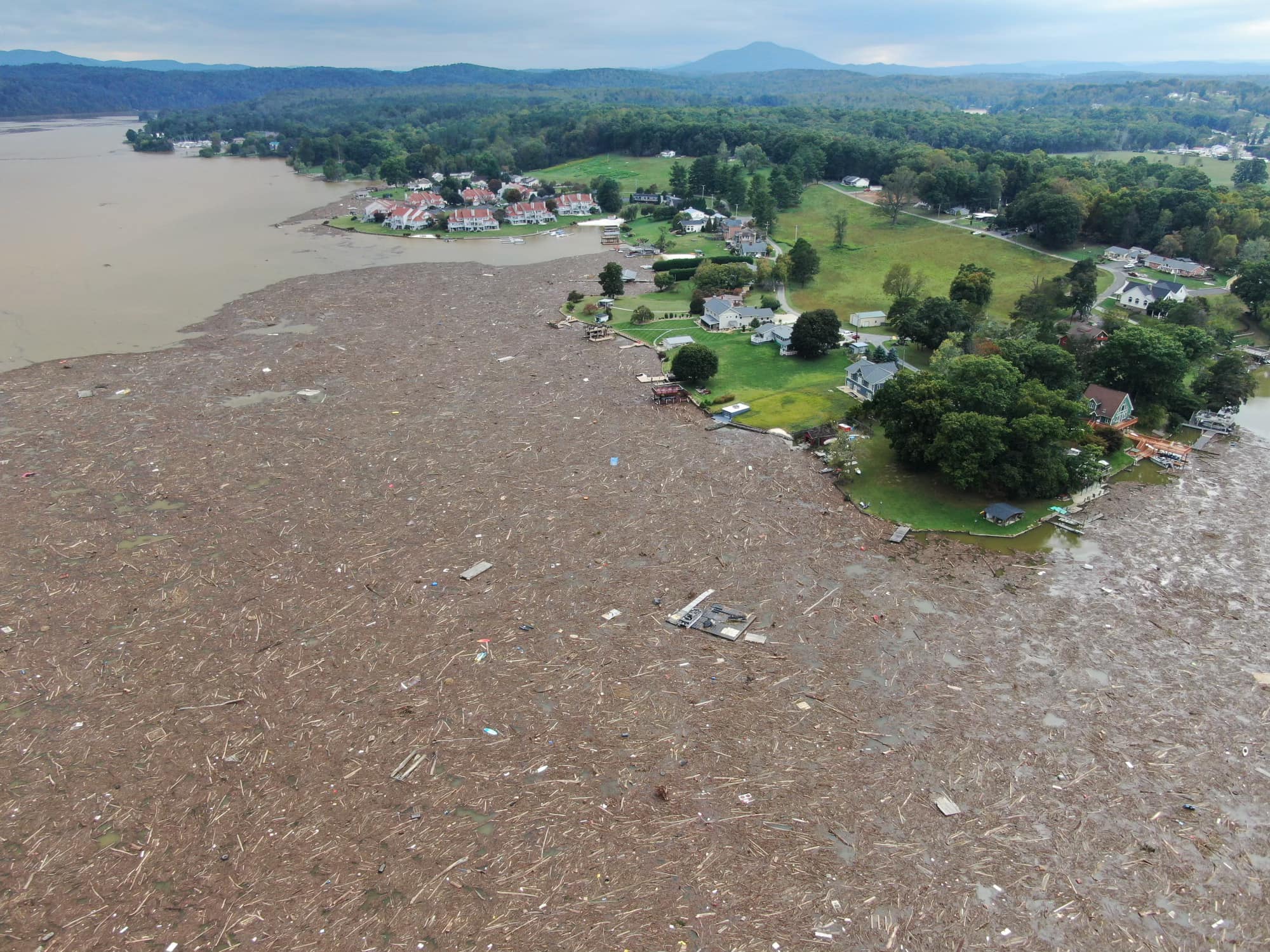
This would seem to be the weather event with the most widespread impact in what is now Cardinal News’ coverage area since the June 29, 2012, derecho — though perhaps those living from the southern Roanoke Valley and Blue Ridge east through Southside could make an argument for the floods connected with Hurricane Michael’s remnants in October 2018 being similar.
The density of power outages in the hardest hit counties in our region was similar to that left in a few more counties by the derecho, which had stronger top wind gusts but for a much shorter time. How Helene’s impact on Southwest Virginia will always be greater than the derecho is in the number of physically destroyed homes, businesses and other property. We had lots of trees down in 2012, some of which crashed into houses causing heavy damage to them, but there weren’t homes turned sideways by the force of water.
Hurricane Isabel in September 2003 is considered the most costly natural disaster in Virginia history, a title it will likely retain considering the breadth of land area and population it affected with stronger winds and similar flooding, plus the coastal impacts not seen since the 1930s on the commonwealth’s shore. Oddly, Helene’s area of greatest impact almost exactly fills the section of the state least affected by Isabel, like a puzzle piece — much of Southwest Virginia was untouched or only lightly affected by Isabel, which tracked northwest from the North Carolina Outer Banks to Northern Virginia.
Disaster finds everyone, given enough time — in this case 21 years. 
In considering the factors that made this particular tropical entanglement so bad for Southwest Virginia and the western Carolinas, we begin with the baseline understanding that our region’s mountainous terrain both lifts moist air flow for greater condensation into heavy rainfall and channels runoff more steeply into drainage channels that intensify flooding and mudslides. I don’t think many of you need that explained. “The rain falls differently here,” Cardinal News founding editor Dwayne Yancey described in a Monday opinion piece about impacts of Helene on our region.
Below we explore some other major factors that contributed to Helene’s fury in the Appalachians. 
Predecessor rain event
Perhaps the most important concept in understanding why Helene was so catastrophic for the western Carolinas extending into eastern Tennessee and Southwest Virginia is that there was already a hurricane’s worth of rain before Helene itself took the stage.
Moist southeasterly flow influenced but not directly connected to Helene, then a rapidly intensifying hurricane in the eastern Gulf of Mexico, banked moisture against both a stalled cold front and our Appalachian mountain ridges. This caused a band of heavy rain that more or less remained stationary in a north-south line over the western Carolinas into Southwest Virginia.
For areas west of Interstate 77, it rained almost constantly much of Wednesday and Thursday, with some amounts already topping 4 inches before the hurricane even made landfall in Florida. Intermittent periods of heavy thunderstorms rumbled farther eastward. 
Predecessor rain events, or PREs, similar to this one are a known and well-studied phenomenon that often occur hundreds of miles north of many, but not all, hurricanes. What was unusual this time is that the main body of the tropical system ultimately tracked right over where all that preceding rain had occurred. It is more commonly the case that the hurricane ends up tracking some distance east of where the PRE has occurred.
The PRE by itself was already causing flooding, and the weakening hurricane circulation would have caused remarkable flooding in the Appalachians by itself. Together, the heavy rain from the PRE and the tropical system together, combined with the steep terrain, moved this event from disastrous to catastrophic. 
Upper-level low capture.
Helene’s sorority sisters are Sandy (2012) and Hazel (1954).
Those were each hurricanes that were captured and ultimately absorbed into an upper-level low pressure system. As a result, each of those storms had a much longer life of wind and heavy precipitation (some of it was snow with Sandy) than most hurricanes after landfall.
The upper-level low enhances and extends the wind energy by adding high-altitude wind support to the typically fairly shallow tropical circulation that immediately starts degrading as soon as it moves over land. It can also cause the system to speed up its movement inland, allowing strong circulation to penetrate deeper inland for higher wind.
Southwest Virginia does not typically see prolonged 40-60 mph wind gusts from a hurricane that makes landfall on the Gulf Coast, but the upper-level wind support helped make that happen with Helene. It was comparable to what happened with Hazel after its Category 4 swipe to the Myrtle Beach-Cape Fear area of the Carolina coast in 1954, retaining powerful damaging winds across Virginia all the way to Canada. 
The influence of an upper-level low can also turn a tropical system’s movement to atypical angles.
In this case, the north then northwest pull on Helene kept its counterclockwise spin focusing soggy easterly to southeasterly wind flow on the mountains of the Carolinas and Southwest Virginia for longer, allowing an extended period of upslope flow with the mountains lifting and wringing out tons of rainfall as they were blasted with tropical storm winds that reached hurricane-force gusts in some North Carolina higher elevations. A more typical seasonal atmospheric pattern would have carried Helene’s remnant circulation more northeast, reducing the period and intensity of upslope flow into the mountains.
This is comparable to Sandy, a hurricane transitioning into a powerful extratropical storm that made a never-before-seen perpendicular northwest-moving hit on the New Jersey coast in October 2012, amplifying both wind and storm surge in areas that normally get a glancing blow from tropical systems paralleling the coast. 
Helene’s odd northwest turn also kept Southwest and Southside Virginia in the northeast quadrant of the storm’s circulation unusually long, where there is the most wind shear to give rain bands an extra spin, leading to a series of 21 tornado warnings on Friday and at least two tornado touchdowns in Pittsylvania and Bedford counties.
Becoming one with the sprawling upper-level low also allowed Helene’s ghost to haunt us again Sunday through Tuesday, with 15 more tornado warnings issued Sunday afternoon mainly in Henry, Franklin and Pittsylvania counties, then persistent slow-moving bands of rain that caused some roads to flood in Southside on Monday night. Hopefully by the time you are reading this late Wednesday, we will finally be getting free of Helene’s lingering showery effects. 
Historical repeat or climate future?
This argument has broken out a few times on social media in the aftermath of the Helene catastrophe. Someone posts a photo from the devastation and makes a statement about how it is an unprecedented event in modern times that will become a “new normal” because of human-influenced climate change. Then, someone posts in reply that Asheville and western North Carolina suffered a very similar flooding episode in 1916 and this kind of thing is just old-fashioned weather and inevitably will recur.
Both thoughts can have truth in them.
Hurricanes moving inland and throwing vast amounts of moisture against our mountains as they weaken inland isn’t anything remotely novel. Check any list of top river crests for gauges in our region and most of them are connected to some tropical system of our past. Camille in 1969, Agnes in 1972, Juan in 1985, Fran in 1996, Jeanne in 2004 and Michael in 2018 are among the top culprits for record or near-record flooding. And the New River this past week, for all of Helene’s might, still came up short of the August 1940 flood at the Radford gauge, spawned by the inland remnants of a hurricane.
Getting 20-30 inches of rain in three days is monstrously catastrophic, as we’ve seen in North Carolina, but for anyone thinking that’s the first time that’s ever happened in the Appalachians, Nelson County in 1969 wants a word. That much fell in 6-12 hours.
The Asheville flood of 1916 was indeed a real thing, also connected to hurricane remnants, and strikingly similar to what’s going on now, if you read historical accounts of it. Many river crests in western North Carolina set records over the weekend by topping the 1916 flood.
So, yes, tropical systems moving inland dumping incredible amounts of rain on steep Appalachian terrain, causing jaw-dropping mudslides and flooding, is something that happens every now and then, something that has happened many times before and we know will inevitably happen again. Every community in our region should prepare accordingly.
That properly noted, there are also well-studied and well-documented changes in climate that raise the specter that these kind of extreme flooding events may be becoming more frequent and more extreme.
Global ocean and particularly Gulf of Mexico sea surface temperatures are among the warmest observed, and August was the Earth’s 15th month in a row calculated as having the warmest average air temperature for that particular month, dating to the late 1800s.
Warmer sea surface water and warmer air temperatures, on the whole, lead to deeper moisture transport from the ocean to inland areas. Several studies have found heavier downpours occurring more often at farther north latitudes than in the past. With favorable atmospheric conditions above them, hurricanes also have the ability to strengthen more rapidly over warmer waters. 
Global climate warming has been likened to the steroid era in baseball. A 1990s slugger didn’t hit 70 home runs entirely because of steroids, but he probably did hit 20 or so more than he otherwise would have naturally. It wouldn’t be possible, however, to go back and figure out which 20 particular home runs were individually the result of steroid juicing. Some of those home runs also probably went farther than they would have otherwise.
Similarly, it is expected extreme weather events will increase in frequency or gain intensity, as seen over time, with overall warmer temperatures. Rather than trying to parse out dubious claims about whether a particular weather event would or would not have occurred without a warmer climate, studies are increasingly focused on determining how much particular weather events were enhanced by warmer temperatures. Some early analysis suggests Helene contained 20 to 50 percent more rainfall because of the warmer oceans and air.
(For a deeper dive into the climatic factors, see meteorologist Dan Stillman’s piece in The Washington Post linked here. The North Carolina State Climate Office has also issued an extensive “rapid reaction” analysis of Helene’s effects on that state’s western mountains, linked here.)
Pondering either historical repetitiveness or a changing climate future, or both together, gets us to the same place that begs for heightened preparedness on a regional, community and personal level.
Something similar to or greater than the flood of 2024 in Asheville or Damascus, the flood of 2018 at Danville, the flood of 1985 at Roanoke and the flood of 1940 at Radford will happen again. And it might come sooner than we would think. 
Journalist Kevin Myatt has been writing about weather for 20 years. His weekly column, appearing on Wednesdays, is sponsored by Oakey’s, a family-run, locally owned funeral home with locations throughout the Roanoke Valley. Sign up for his weekly newsletter:
