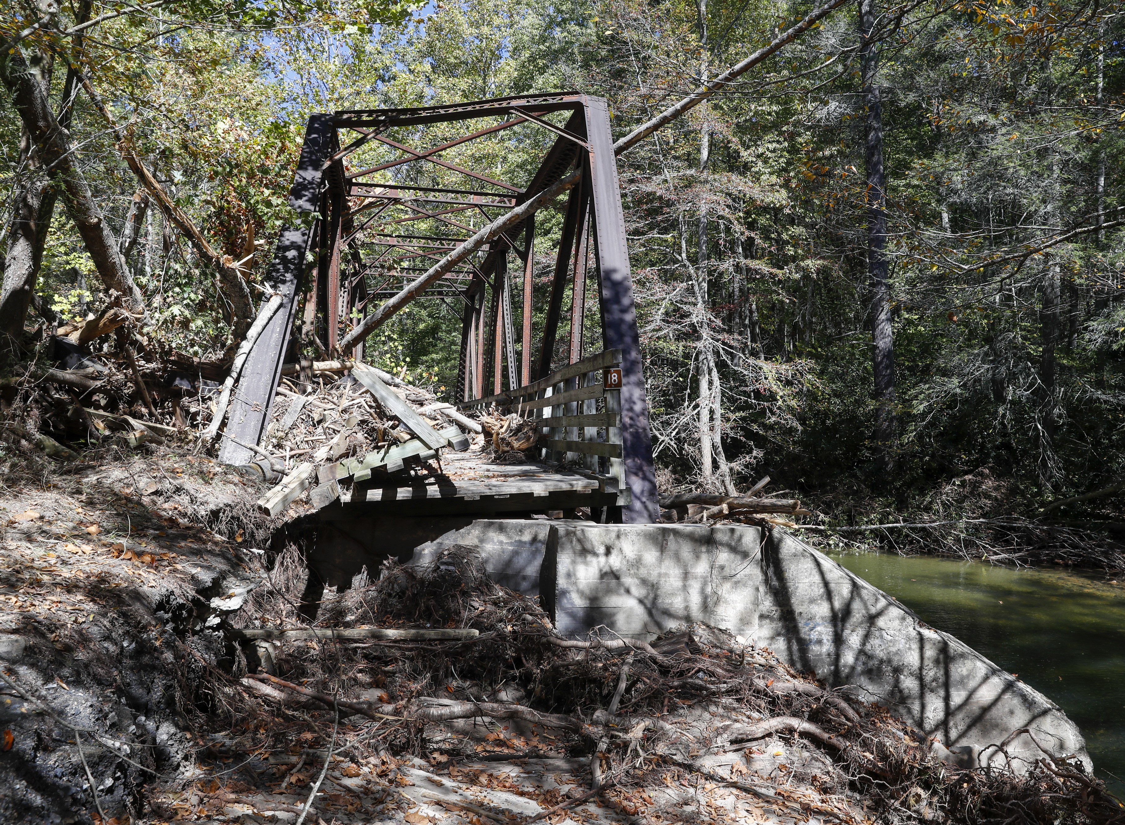
Nearly a mile up a washed-out, now-closed two-lane section of U.S. 58 between Damascus and Konnarock rest the remains of a steel trestle that was part of the beloved Virginia Creeper Trail.
Battered by flooding and high winds from Hurricane Helene, the rust-colored structure known as No. 18 was knocked off its foundation and came to rest against the Whitetop Laurel Creek bank. It’s covered by brush, limbs and trees; a closer look reveals that portions of the No. 19 trestle were carried downstream by a wall of water and washed into the steel structure.
The two trestles are among 32 that dotted the section of the Virginia Creeper Trail between Damascus and its end at Whitetop Station near the North Carolina line. Eighteen of the structures were destroyed by the remnants of the storm on Sept. 27, according to Ed Wright, area ranger of the Mount Rogers National Recreation Area, which includes the trail.
Thirteen trestles are standing but presumed damaged, while one has reopened, according to the latest information released Monday. There is hope that the next trestle, No. 17 in Damascus, can open soon after some repair.
It has taken two and a half weeks to assess some trestles because parts of the trail still aren’t accessible. That is particularly true in the areas of the closed section of 58 and Taylors Valley, a hard-hit community near Damascus, Wright said.
“More than half of our 32 trestles will require full replacement or a rebuild essentially,” Wright said. “And there are several sections of trail itself that are altogether missing, and we don’t know exactly how long … but parts of the trail are just missing. It’s been taken by the creek.” 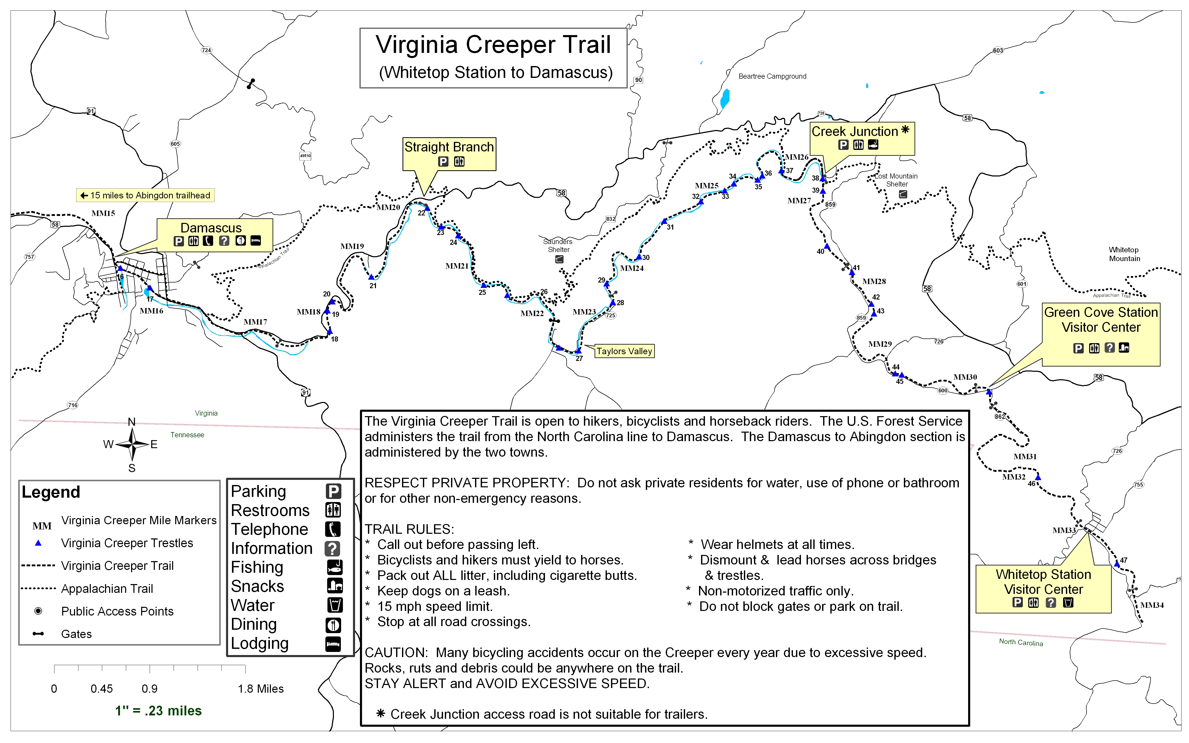
The trail’s repair in that area will be hindered by the state of that section of 58, the same road used by shuttles to transport bike riders to Whitetop. The road starts as two damaged lanes, devolves into one lane and then a big gulch. It will be difficult to get materials normally transported on large vehicles in and out for repair of both the road and the trail, according to an official with the Virginia Department of Transportation.
It’s too early to know how much it will cost to repair the trail so it can reopen, but trail, town and county officials and state and federal lawmakers say they are determined to rebuild it.
How long it will take to get that section back in shape to fully reopen also isn’t known. Some locals fear it could take years to rebuild. Others are more optimistic.
Most Damascus residents make their living from the tourism created by the trail, which allows hiking, biking and horseback riding. The first half of the trail from Abingdon to Damascus is now open.
The hope is the second half can be reopened in about a year with sections opened as they are repaired, said Lisa Quigley, executive director of the Virginia Creeper Trail Conservancy. 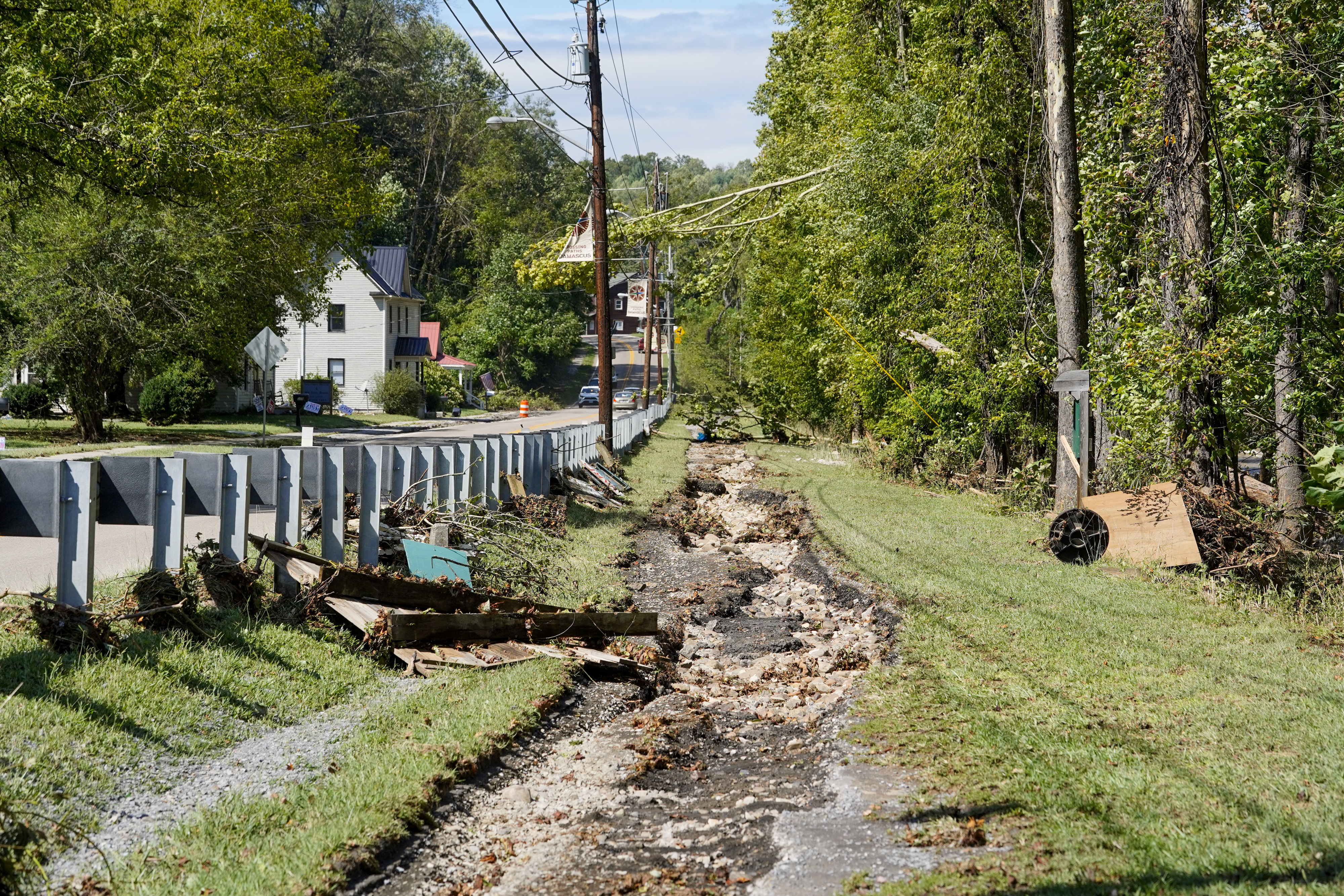
The trail is the ‘lifeblood’ of Trail Town USA
More than one local official has called the Creeper Trail the “lifeblood” of Damascus in recent days, including Washington County Administrator Jason Berry and Town Manager Chris Bell.
The Washington County town of around 767 residents is filled with businesses that cater to the 200,000 visitors to the trail each year — from businesses that rent bikes and shuttle people back and forth, to the bed-and-breakfasts, cafes, ice cream shops and brewery.
“The majority of people that live in Damascus work at a trail-related business, whether it’s a bike shop or restaurant or a T-shirt store. It’s all tied to the Creeper Trail,” Quigley said. “That number is not as significant as you move away from Damascus, but it’s still significant.”
Currently, nine permitted bike shops operate in the town, according to Wright. Owners of the bike shops have been difficult to reach because most remain closed, and those who were reached declined to be interviewed for this story.
The Appalachian Trail, which was also damaged by Helene in this area, also runs through Damascus, which is known as Trail Town USA. But that trail doesn’t have the economic impact on the town that the Creeper Trail has because many on the AT are day-hikers who don’t spend the money on local goods and services like Creeper Trail enthusiasts, local officials say.
Susan Coleman lives in a house that is within a block of both the Creeper and the Appalachian trails. She and her husband, John, operate a gift shop on Laurel Avenue downtown called Discover Damascus, where they sell T-shirts, sweatshirts, mugs and locally made gifts and crafts. 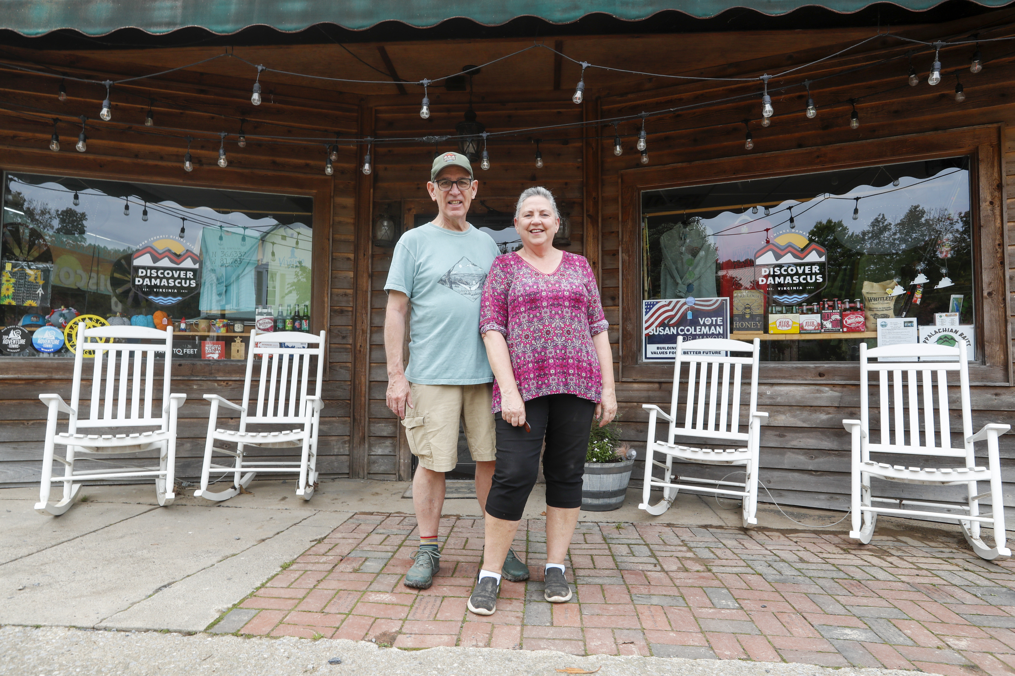
The store has been closed since the storm because it sustained some water damage, but they plan to open in a couple of weeks, she said late last week.
She admits she’s worried about the Creeper Trail’s partial closing and the effect it could have on their business.
Mike Rush, a longtime Damascus resident who represents the town on the county’s board of supervisors, said local businesses are already being impacted. His wife and son own six regular rentals and one Airbnb and they have had 31 cancellations, he said Tuesday.
The trail is so popular it was named No. 2 on a list of the top 10 recreational trails in the U.S. by USA Today in 2023.
It is also one of the top draws to the nearby town of Abingdon, but the town doesn’t depend on it as much as Damascus, said Abingdon Town Manager Mike Cochran.
The full economic impact of the trail on Damascus and the rest of the county isn’t known. The last study was done in 2007. In 2022, a 202-page master plan aimed at guiding and sustaining the trail for the next 10 to 20 years was conducted by a company called Equinox, a consulting firm based in Asheville, North Carolina. One of its many recommendations was that a thorough economic impact analysis be conducted.
Quigley, who heads up the trail conservancy, said they were getting close to starting the economic study when the storm hit.
Washington County Treasurer Fred Parker said the partial closing of the trail could be “devastating.” He estimates the county and its towns could lose $200,000 in sales tax revenues over a year, and that doesn’t include lodging or meals taxes.
To try to help the businesses that will be negatively impacted, the county has set up a $600,000 fund for small business grants. The county put in $200,000, that amount was matched by the county’s Industrial Development Authority, and $200,000 came from the Wellspring Foundation. Wellspring contributed a total of $800,000 to the county for flood relief efforts.
Berry said the county will start writing the checks later this week.
Businesses can apply for the $7,500 grants on the county’s website at www.washcova.com. 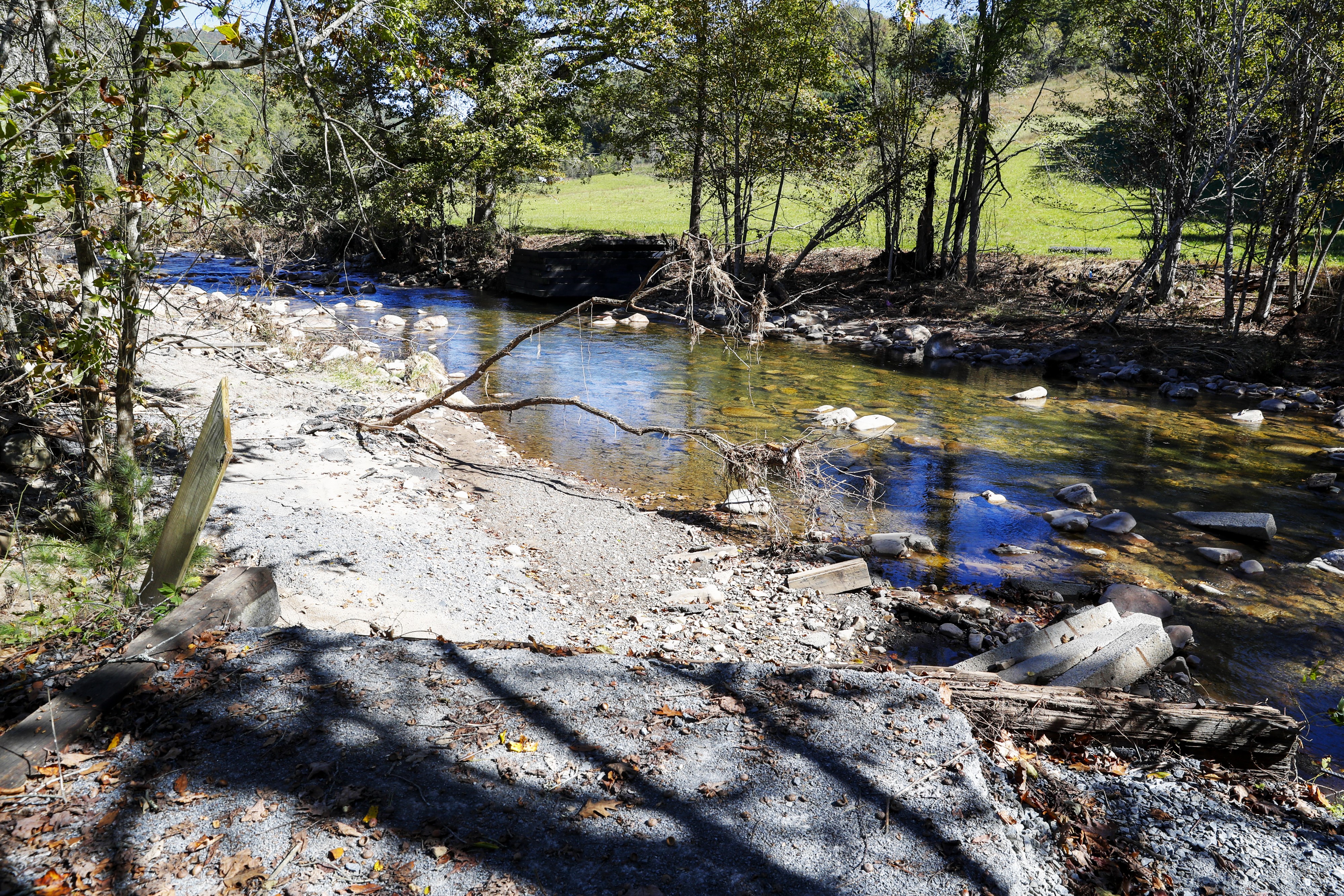
Visitors discover the lesser-known end of the trail
The trail is a 34-mile rail-to-recreation trail that opened in 1987. There are 47 trestles between its start in Abingdon and its end at Whitetop. The first 15 trestles are owned by Abingdon and 16 through 47 are managed by the U.S. Forest Service.
The good news is that the first half of the trail sustained far less damage than the second half. As of last weekend, the section of trail between Abingdon and trestle No. 16 in downtown Damascus is fully open, which Bell said was a boost for residents and business owners.
Local officials are trying to take advantage of this by working with the bike/shuttle businesses in Damascus to lure bikers to the section of the trail between Abingdon and Damascus.
“A lot of visitors don’t experience that section. They’re used to being dropped off at the top of the [Whitetop] mountain and coasting downhill for 17 miles,” said Bell. “But there’s another 17 miles that’s equally as beautiful, and you pass through not only some mountainous areas, but also a lot of farmland and you pass by the Middle Fork and the South Fork of Holston Lake. And so there’s just a lot of beautiful trestles, a lot of beautiful scenery.”
The first section of the trail is more level in spots than the trek between Damascus and Whitetop and will require more pedaling, he added.
Coleman said she’s hopeful people will start to use the first section of the trail more, and she added that a lot of people are riding e-bikes, which require less effort. She also noted that several restaurants have opened in Damascus in recent days as a hopeful sign.
The storm also came at the trail’s busiest time of year, when its already scenic beauty is enhanced by the fall show of red, gold and orange foliage combined with pleasant temperatures and less humidity.
The hope is to still get some of the October business, Bell said.
In the meantime, the next goal is to work on getting the No. 17 trestle stabilized and reopened, which would mean the trail was open through the town, he said. It’s going to take a little more work and time to remove all the debris and get it tested by engineers, he said.
All but six of the 32 trestles managed by the Forest Service are wooden structures originally inherited from the railroad in the 1970s. The remaining six are made of steel truss with wooden decks.
Although the wooden trestles add to the trail’s “aesthetic,” they are old and more vulnerable to the elements, Wright said.
Rush, who is a builder, said the old trestles were built to hold heavy trains, but the new ones do not need to be and can be done more quickly and at less cost. He pointed out that many of the trestles were more than 100 years old.
That condition of the trestles was a major concern in the 2022 master plan study. 
Condition of the trail draws ‘massive amounts’ of interest
Wright said he has received “massive amounts” of interest from federal, state and local agencies about the state of the trail and how soon it can be rebuilt.
Gov. Glenn Youngkin was in Damascus the morning after the storm hit and five days later, he was back to tour some of the damage with Republican vice presidential nominee JD Vance.
Youngkin has since tasked the Virginia Department of Emergency Management with forming and leading a task force comprised of local officials, federal representatives, state agency members and the Creeper Trail Conservancy. The task force will assess the current status of the trail, evaluate the extent of the damage and work “diligently to ensure the trail’s recovery and long-term sustainability,” said Christian Martinez, the governor’s press secretary.
Fundraising efforts for the Virginia Creeper Trail and Damascus
The Virginia Creeper Trail Conservancy’s rebuilding fund: www.vacreepertrail.org.
The Damascus Strong direct fund: www.visitdamascus.org/ (or visit any Bank of Marion branch). Donors should specify whether they are giving to the direct fund, the Creeper Trail, downtown or emergency services.
Small businesses affected by the damage to the Creeper Trail can apply for $7,500 grants at www.washcova.com.
The VDEM public affairs office said Monday that the task force has begun its “initial phase of operations,” and that teams of experts have been deployed to conduct detailed damage assessments and are working closely with local authorities, environmental specialists and engineers to collect data that will be used to create a roadmap for restoring the trail safely and sustainably.
Since the governor’s task force was formed, Wright said VDEM is now holding daily calls with his agency and a number of others, including VDOT, the state Department of Forestry, the state conservation and recreation department and the Federal Emergency Management Agency.
U.S. Sens. Mark Warner and Tim Kaine, both Democrats from Virginia, have toured the Damascus destruction, as has U.S. Rep. Morgan Griffith, R-Salem. In separate statements, the trio said that the trail is an important economic asset, and that they are waiting for the damage assessments to be completed and will do what they can to make sure federal assistance is available to ensure the trail is repaired and reopened.
“There is zero question, no doubt in anyone’s mind that the trail will be rebuilt,” Quigley said. “I can’t think of a time I’ve seen where so many different levels of government, so many different organizations have worked so closely to get one single goal accomplished. I think that should give every one of us all the reason to remain optimistic that this is going to be completed in an effective but expedient way.”
For now, those used to starting their Creeper Trail journey at Whitetop will have a new starting point near downtown Damascus, just around the corner from bike shops, restaurants and rentals that need their business.