


On the hottest Virginia summer days, heat doesn’t treat every neighborhood in your city the same.
In fact, temperature varies an average of 9 degrees within the boundaries of your locality on a hot afternoon depending on the characteristics of your surroundings, according to a Virginia Heat Watch study published in February.
The study, conducted by more than 200 data-collecting volunteers and a team of climate researchers from institutions in the Virginia Foundation for Independent Colleges, found that the number you see on your weather app often doesn’t represent the heat you experience on your block.
In part, that’s because the temperature you see on your screen was recorded at the nearest weather station. For most Virginians, the closest station is at the closest airport, said Karin Warren, one of the study’s leaders and the Herzog Family Chair of environmental studies and science at Randolph College.
More significantly, temperature varies within communities because of how it’s impacted by elements of our environment — the trees that provide shade, the paved parking lots that hold heat, and the cool breeze that runs over your favorite neighborhood creek all affect “how hot hot can really feel,” Warren said.
By collecting temperature data and creating heat maps, Warren and her team documented how highly developed areas with lots of heat-trapping materials like asphalt, cinder block and roadways have higher temperatures throughout the day, while areas with features such as parks, urban forests and bodies of water feel cooler.
Warren and her colleagues’ research also shows that the discrepancies in our built environment often aren’t random. There’s a correlation between which areas are hottest today and which ones were historically redlined, or systematically denied loans and insurance in the early 20th century due to their racial or ethnic composition, she said. With a history of underinvestment, those neighborhoods often have less tree cover, more asphalt lots, and smaller housing plots that don’t leave room for green space today, Warren said.
“The profound thing there is that even though the practice [of redlining] was technically outlawed with the Civil Rights Act in 1968, those areas are still seeing effects today,” she said.
Even a few degrees can make a big difference in everyday life during heat waves, Warren said.
Extreme high temperatures have negative effects on human health, Warren said, commonly seen in the forms of heat exhaustion and heat stroke.
High temperatures also hurt the bottom line, Warren said. Hot days lead to more air conditioning and a bigger electricity bill. That air conditioning also contributes to the increased energy consumption and greenhouse gas emissions already exacerbating climate change, Warren added.
Warren said there are many solutions that city planners and homeowners alike can consider to help make their communities cooler. The primary strategy is to plant more trees, which not only provide shade but also cool the air as water evaporates from their leaves, Warren said.
Other strategies include substituting dark building materials for lighter ones so that heat is reflected, not absorbed, Warren said — think swapping blacktop for bricks or painting roofs white.
When it comes to solutions, Warren said, “It doesn’t have to be putting in a whole new park. It could look more like just putting grassy margins between where a sidewalk and the road is. All of those little things incrementally can add up to a significant impact.”
Warren said her team made heat maps of the 10 Virginia localities in their study — including Southwest and Southside locations like Abingdon and Salem — open access so there is no barrier to learning what areas are most at risk during heat waves. Making existing scientific data accessible is crucial today, Warren said, as the Trump administration is cutting federal funding for future climate research.
“It’s really important for people to understand how funding scientific research affects our everyday lives, our health, and the risks we face from climate change.”
Cardinal News sent five reporters armed with temperature gauges to collect heat readings around their neighborhoods Monday and Tuesday afternoon. Here’s what they found.
The Star City heats up and stays hot
Those with children who play baseball in the summer are well acquainted with sweltering days sitting on metal bleacher seats, waiting for long games to end.
Parks are supposedly cooler from the shade of trees. There’s not much shade at a baseball field. Placing a thermometer on the baseball diamond in Raleigh Court Park in Roanoke around 3:20 p.m. on Monday confirmed that it is indeed hotter at the baseball field lacking shade than the average temperature in Roanoke suggests.
The real temperature on the Apple Weather app, which is pulled from the Weather Channel among various other sources, read 91 degrees Fahrenheit, and the thermometer read 95.4 degrees — a gentle reminder to keep young athletes hydrated, despite what the weather app reads.
Lucky parents of kids playing in evening games can expect to be much more comfortable. Placed at the same spot at 8:45 p.m. Monday night, just after sundown, the thermometer read 84 degrees Fahrenheit — equal to what Apple Weather read at that time.
Dense urban areas and downtowns tend to be hotter
Heat island mapping conducted in Roanoke during summer 2020 confirmed a commonality for most cities: Dense downtown areas tend to be hotter than more suburban areas.
The national study, in which Roanoke was one of 13 cities studied, used over 30,000 data points and found 15-degree Fahrenheit temperature variations across the city.
Downtown Roanoke was, according to the heat island map, one of the hottest areas in the city. But placing the thermometer in the shade actually produced a cooler reading than what Apple Weather predicted.
About 3:05 p.m. Monday in Roanoke, the Apple Weather temperature for the city read 91 degrees Fahrenheit. The thermometer sat in its box in a partly shady patch of grass right outside the city’s municipal building, at the intersection of Campbell and Church avenues. The temperature read 90 degrees Fahrenheit.
Roanoke’s heat-mapping data also shows the area around Williamson Road to be a hotspot for extreme heat. At the intersection of Williamson and Thurston Avenue in Northeast Roanoke, the thermometer was placed in a particularly sunny patch of grass right off busy Williamson Road. 
After baking in the heat for five minutes, with not a tree or cloud in sight to provide shade, the thermometer read 98.8 degrees Fahrenheit, significantly higher than the Apple Weather app’s reading of 91 degrees. This was around 2:40 p.m. Monday.
Over 20% tree canopy reduction in Roanoke in 10 years
One of the most important factors that goes into how hot a city is is tree canopy coverage —- or lack thereof.
In 2010, Roanoke’s tree canopy coverage was 47.9% — meeting its goal for that year of 40%. But more recent numbers from 2019 show that tree canopy is down to 26% in the city.
According to the City Plan 2040, in 2008, budgeting for urban forestry was reduced. The city has since relied on volunteers and nonprofits for planting new trees, and maintaining existing ones.
Vice Mayor Terry McGuire said in a recent interview that the city doesn’t have the necessary staff or resources to keep up with replacing trees and caring for young trees that are planted, which are more vulnerable to invasive species and disease in their first few years, he said. McGuire is a former Clean Air Act federal policy advocate.
Tree canopy provides 10 to 15 degrees of cooling on hot summer days, McGuire said. Data connects extreme heat to worsening of cardiovascular and respiratory conditions, McGuire said, but also mental health — data shows improving the green space in a neighborhood lowers overall violent crime levels.
Climate change has made trees weaker, McGuire said, as has extreme weather and droughts in past years. The city now overrelies on contractors to plant trees, he said.
Nonprofit groups like the Tree Stewards in Roanoke are “doing the Lord’s work,” McGuire said, in planting trees in the city, but they can’t sustainably replace city staff.
“It’s not fair, realistic or responsible to put all or even most of that work on citizen volunteers,” McGuire said. “They should be [there] to supplement or complement what the city is doing.”
Roanoke’s comprehensive plan includes action items to increase the coverage such as: increasing education, performing tree assessments, creating incentive programs and increasing tree planting requirements.
McGuire said he will continue to push for an overall increase on the city’s parks and recreation department budget, and a “robust” action plan to get back to 40% tree canopy coverage.
“We’ve done a great job of building awareness here,” McGuire said. “We have to put our money where our mouth is.”
Heat’s in Danville’s comprehensive plan
A handheld temperature gauge read 101.7 degrees Fahrenheit at Danville’s Community Market parking lot on Monday afternoon, even though the Apple Weather app said it was 90 degrees.
This parking lot, like most of the city’s River District, is considered a heat island — an area that has higher temperatures than the city’s average, according to a heat index map.
Just across the parking lot, at one of the starting points for the city’s Riverwalk, the gauge read 97.9 degrees in the shade.
Tree coverage has a significant impact on what the heat actually feels like, regardless of where you are in the city.
Danville is hot and set to get hotter, according to the city’s comprehensive plan, which includes suggestions on how to tackle rising temperatures and the public health risks they pose. 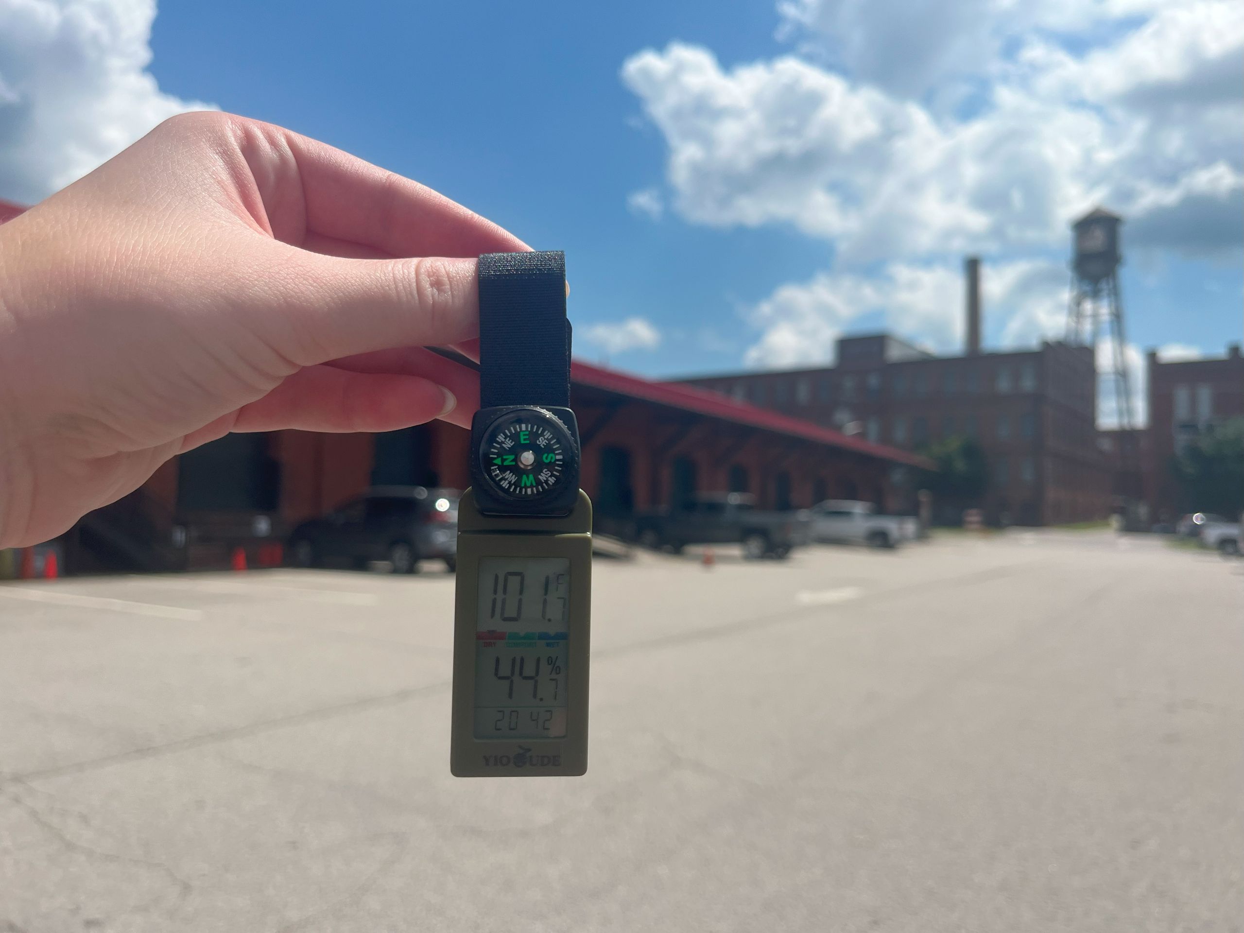
The summer of 2023 was the hottest on record globally, says the plan, and temperatures are only slated to continue to rise.
By 2070, the number of annual days over 95 degrees in Danville will increase from an average of eight to an average of 50, according to a 2022 community climate study of the city.
Danville has been experiencing an explosion of economic growth in recent years, which brings with it new construction, new industry and increased population density — all things that can contribute to a locality’s heat index.
Extreme heat is a city-wide issue. It not only poses risks to individuals, especially those who are older or have lower incomes, but it can also strain emergency services and skyrocket energy usage.
The city is working to be proactive about rising temperatures in several ways.
Last year, Danville began participating in a new urban forestry campaign to expand and preserve its tree canopy, which can lower temperatures and create other environmental benefits.
The campaign, called the Community Forest Revitalization program, is run by the Virginia Department of Forestry and will prioritize factors like green space, shade, flood resiliency and air quality, starting in neighborhoods that historically have been left out of such conversations.
Martinsville, Petersburg and Hopewell were also selected to participate in this program.
The city’s recently updated comprehensive plan includes a section on environmental goals, with a focus on rising temperatures. The plan highlights ongoing efforts and suggests initiatives for the future.
“There are opportunities to tackle [rising temperatures] with infrastructure like street trees to provide shade on highly trafficked streets, cooling shelters at public facilities like fire stations, and more,” it says.
The plan also includes a heat map of the city, created with data from the Trust for Public Land.
The map identifies heat islands and can inform the best locations for resources like cooling shelters and infrastructure like trees.
Much of Danville’s River District, a more densely populated area of the city, has higher-than-average temperatures, according to the map. This area is characterized by redeveloped tobacco warehouses, a tight network of paved or cobblestone streets and several surface parking lots.
Temperatures are also high in areas with lots of industrial activity, like the Goodyear plant, and near the local airport, which has lots of paved areas and few trees.
Many single-family neighborhoods in the city, like the Westover Hills, Woodbury Hills and North Danville communities, are around average city temperatures. Compared to the River District, these neighborhoods have more sprawling streets, more tree coverage and grassy yards.
Temperatures are coolest along the Dan River and in city parks, according to the map. But in sunny areas, even in these places, temperatures can still feel warmer than they are.
On the riverbank on Monday, where temperatures are usually cooler than the city average, the gauge read 99.3 degrees in a sunny spot and Apple Weather measured 90 degrees.
At night in the Community Market lot, the gauge read 85 degrees — the same temperature that Apple Weather said it “feels like” due to humidity, though the app’s official reading was 82 degrees.
This variation illustrates the urban forestry campaign’s central point, that direct sunlight inflates temperatures, and that trees are a vital line of defense from extreme heat.
Expanding the city’s tree canopy to offset urban heat island impacts is one of the comprehensive plan’s suggestions to meet environmental and public health goals.
The plan recommends adding street trees along key corridors, considering densifying the existing tree canopy in suitable locations, and spearheading yearly tree-planting campaigns.
Residents affected by extreme heat can go to a cooling shelter at Redemption Center Church, on 625 Shelton St. The facility is open daily from 10 a.m. to 6 p.m. when temperatures rise above 90 degrees.
Lynchburg’s colleges reckon with rising temps
When Lynchburg’s college campuses are quiet for the summer, heat speaks for itself.
Lynchburg’s temperature bounced between 90 and 91 degrees in the afternoon hours of July 28, according to the Weather Channel weather app. Cardinal News’ temperature readings at college campuses ranged from 89 to 99 in the same time window.
The hottest campuses on Monday were Central Virginia Community College and Liberty University, located on opposite sides of Wards Road. Cardinal News’ average temperature readings of 99 and 96, respectively, showed both campuses climbing above the weather app’s reported temperature.
Spokespeople from both schools said that ongoing tree-planting initiatives aim to help keep campus cooler. A Liberty spokesperson added that the expansion of the campus’ Hydaway Lake from six to 31 acres should also help to lower temperatures.
But it’s difficult to counteract the effects of development along Wards Road — including strip malls, big-box stores and a seemingly endless array of parking lots — which traps heat and makes the area one of the warmest in Lynchburg, Warren said. Cardinal News recorded one parking lot along Wards Road to reach 100.6 degrees on Monday afternoon, or 10 degrees above the weather app reading. 
Of the 10 Virginia localities that Warren’s team studied, Lynchburg showed the second highest range in temperature in a single time window, which shows the impacts of highly developed areas like Wards Road on microclimates. As Lynchburg’s temperatures increase year after year, developed areas will only get hotter, Warren said. According to the National Weather Service, the monthly average July temperature in Lynchburg increased from 72.1 in 2000, to 78.6 in 2010, to 81.2 in 2020.
The greater Lynchburg area is home to more than 22,000 students and seven colleges and universities, according to the city’s website. Combined, the campuses within city limits cover about 12 square miles. That’s about a quarter of Lynchburg’s 49-square-mile footprint, which means quads are more than gathering spaces for students — they’re big influencers of microclimates within the city.
For example, wooded campuses far removed from the Wards Road commercial corridor saw cooler temperatures on Monday afternoon. Randolph College, at the city’s northern border, had an average temperature of 92 along its winding brick footpath. The University of Lynchburg, covered in shade from the trees in its central greenspace called the Dell, had an average temperature of 89.
As the sun went down, wooded campuses let go of heat quickly, too. At 8:15, Cardinal News recorded the University of Lynchburg’s temperature to be 79, which was 6 degrees cooler than the weather app’s reading at that time.
The cooler temperature makes a difference for the surrounding community, said Lynchburg resident Izabelle Simoes. She lives a five-minute drive away from the University of Lynchburg’s campus, but makes the trip to the Dell for evening walks because she can feel that the air is not as hot.
She pays special attention to the weather so her 10-month-old golden retriever, Eevee, can stay safe from burning her paws on the pavement, getting heat stroke or facing other heat-related health risks. When Eevee’s zoomies set in, cool, shaded green spaces become that much more important for Simoes’ peace of mind, she said.
This week, the city of Lynchburg is running four cooling centers to keep residents out of the heat. They are located at the main branch and downtown branch of the library, the lobby of the Department of Human Services building, and Salvation Army, according to a city press release.
In Bristol, the stakes are high, and so are the parking lot temperatures
Those heading inside to play the slots from the parking lot of the Hard Rock casino late Tuesday afternoon might have thought it was a lot hotter in Bristol than it actually was in other parts of the city.
A reading on a digital thermometer around 5 p.m. showed the temperature to be around 96 degrees, while the temperature displayed on the Apple Weather app showed the real temperature to be 10 degrees cooler.
Parking is at a premium at the casino, where there’s lots of black pavement, which draws heat in the middle of summer. The temperature reading was taken in the parking lot under sunny skies, which drove up the temperature.
At another of Bristol’s hottest spots, the track next to Virginia High School, the temperature was a little higher than other spots.
A digital thermometer revealed a high of 90 degrees at nearly 4:30 p.m., while the Apple Weather app said the temperature was 87 degrees. The reading was taken on grass next to the pavement. It was cloudy.
With nearly a month straight of toasty temperatures combined with steady high humidity, Bristol area residents might think the summer of 2025 so far has been one of the hottest on record. In fact, it is far from it. 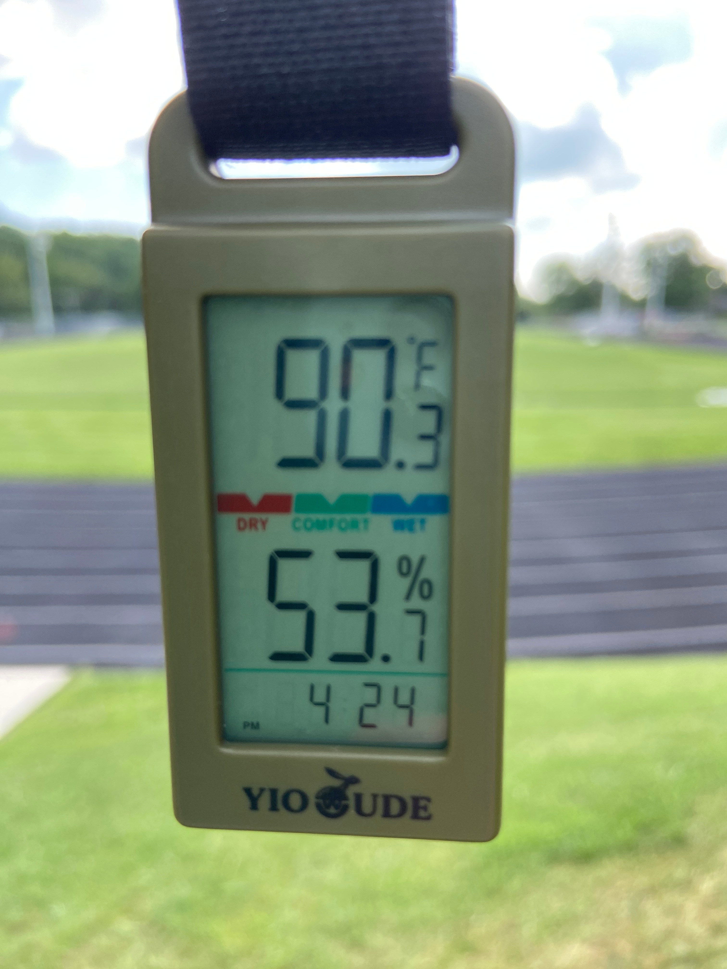
So far this year, through July 28, there have been 13 days when the high temperature reached 90 degrees and above, according to Jeremy Buckles, a meteorologist with the National Weather Service office in Morristown, Tennessee.
“The average is 11 days, so actually we’re only two days above normal, as far as those 90-plus degree days right now,” he said Tuesday.
The record year with the highest number of 90-degree days was 1952, when there were 34 days when the thermometer hit 90 degrees and higher, he said. That was followed by 32 days in 1993. The rankings go back to 1937, he said.
So far, this year’s summer would rank around the 30th-hottest, when considering those numbers, Buckles said.
A check of the high temperatures reached so far this summer is another indicator that this summer hasn’t been the most unbearable.
The temperature readings for the Tri-Cities area, which includes Bristol, are conducted at the Tri-Cities Airport in Blountville, Tennessee. So far this year, the highest temperature recorded there was 94 degrees, Buckles said. In 2024, the highest temperature recorded for the same period was 96, while it was 95 in 2023 and 2022. In 2021, the hottest temperature recorded was 93 degrees.
Mid-July through early August is normally the hottest time of the year for the Bristol area, according to Buckles. The hottest temperature ever recorded at the Tri-Cities Airport was 103 degrees in 2012, he added.
A look at the average temperature is a better overall gauge of how this summer’s heat compares to others, the meteorologist said. The average temperature for June through July 28 was 75.8 degrees. Last summer through the same period, the average temperature was slightly warmer at 76.1 degrees, while it was cooler, 72, in 2023, and the average for 2022 was 75.8 degrees, the same as this year’s, he said.
The temperatures measured at the airport are done carefully, on grassy surfaces and in the shade so they don’t include a lot of extra heat sources, Buckles said. So, for someone who is working on hot pavement or playing in the sun, it can feel a lot hotter and sneak up on people.
He urged local residents to be aware of the effects of high heat and humidity.
“It’s just very, very important for anyone being outside to practice safety,” he said. “Limit activities during the mid to late afternoon, the hottest part of the day when the sun is bearing down the most. Drink plenty of water … and if you’re out a lot, take frequent breaks in the shade or air conditioning.”
In Martinsville, the roots of a solution branch out over the city
A thermometer app gauged a deviation of 10 degrees in two Martinsville locations, with one reading 77.9 and another reading 87.8. Additional readings from a handheld temperature gauge led to similar results.
As cities turn to trees to combat growing temperatures, Martinsville is ahead of the curve.
A past recipient of the Tree City USA distinction and boasting canopy coverage north of 50%, Martinsville’s got more shade than most Virginia cities. How big of an impact do trees have on managing heat?
A comparison of two parking lots, one with a significant canopy covering and one with no canopy covering, provides a compelling answer.
Temperatures at the tree-covered Church Street parking lot reached 89 degrees Fahrenheit toward the end of Tuesday’s workday. Across town, without any canopy coverage above the Kroger parking lot, temperatures reached 102 Fahrenheit.
While both parking lots are located in Martinsville’s Uptown District, the former is in the heart of the Uptown area where trees are abundant. The latter is in more of a commercially focused area where trees are more sparse.
“If you don’t know what a heat island is, please stand in the middle of the Kroger parking lot at midday,” said Christine Stewart, the vice chair of Martinsville’s Tree Board.
The Tree Board, in partnership with the Greene Infrastructure Center, recently mapped out Martinsville and identified a number of hot zones concentrated in the Uptown District. Although both parking lots are in the Uptown District, could the presence of trees be the deciding factor of a 13-degree difference?
Experts like Jeremy Hoffman, a climate scientist with Groundworks USA, seem to think so.
“Trees are nature’s air conditioner,” Hoffman said. “They significantly lower temperatures under them and surrounding them because of their ability to shade surfaces from the sun’s incoming radiation. Everyone knows it feels good to stand under one during a hot day. But they also do another interesting thing. Basically they sweat.”
This is in reference to a process called evapotranspiration, in which the water in plants like trees evaporates and lowers the ambient temperature. Hoffman said that every 10% in additional canopy can translate to 0.5% reduction in temperature.
“The combination of the shade it provides and lowering temperatures through evapotranspiration makes it very efficient natural air conditioners in places that don’t have a lot of trees,” Hoffman said.
Martinsville’s parking lot measurements don’t deviate from Hoffman’s findings. He said that he has seen temperature deviations as high as 20 degrees Fahrenheit in a single city.
In cities where there are a lot of trees, it becomes a question of where they are located. Greene Infrastructure’s heat map of Martinsville gives context to the city’s 59% canopy coverage rate.
“There are neighborhoods and areas that are heavily treed and there are neighborhoods that are sparse in trees,” said Tree Board member Dean Cooke.
Hoffman said this is a reality in many communities.
“We tend to find in cities all across Virginia and around the country, it tends to be wealthier and older neighborhoods, in some cases, that have more trees than in other parts of the cities,” Hoffman said. “We tend to find that post-industrial neighborhoods, places with warehouses and more industrialized history tend to have fewer trees. They tend to be more concentrated in more wealthy neighborhoods in the same city and very much missing in lower income parts of the city and places with a more industrialized past.”
How we reported this story
Cardinal News reporters looked for multiple places to measure the heat — readers sent in suggestions, and we used heat-mapping data to choose the rest. Using the same temperature gauges and method — we placed the temperature gauge in a box to cover it from direct sunlight — we recorded heat in spots that we thought might be hotter than the temperature on your phone’s weather app. We also looked for places that might be cooler, to show how sharp the contrast can be between these microclimates and the number you see on your phone.
